Ok – here’s the bad news straight up. There’s no hiking on the 5th day. Well, I say ‘bad’ news, but by this stage a lot of the group think it’s actually a wonderful thing! On the up side, here’s the view you could wake up to:
Mitre Peak from our room at Mitre Peak Lodge
The reason Ultimate Hikes make this a 5 day experience is because once you’ve walked all the way to Milford Sound, who’s NOT going to want to go for a cruise out on Milford Sound before going home? The bone of contention is when people realise the advertised 5 day / 4 night guided walk includes only 3 full days of actual hiking in the wilderness. But damn it’s worth it!
The clouds that float around the mountains are fantastic. The many moods of Mitre Peak – we were lucky to see it in such spectacular form.
Everyone had packed an extra change of clothes in an overnight bag that Ultimate Hikes had sent on ahead from Queenstown on Day 1. Not having to wear the same hiking gear for the 5th day in a row – on the last day when we weren’t even hiking – was very nice.
Of course, you do have to do a wee bit of walking today – from your room to the bus, from the bus to the ferry, around the ferry while taking photos… you get the picture.
Our boat
Local Maori tribes used to visit Milford Sound, that they called Piopiotahi (after a now-extinct bird) to collect pounamou (greenstone) to make into tools and jewellery. They walked the same route through the mountains as we did, over what is now known as Mackinnon’s Pass. Read more here.
The Lady Bowen Falls, a modest 162m
No matter who you travel with, there are a few things every boat operator on the Milford Sound will do. One of them is going right up to a waterfall cascading down the side of a cliff… one might even say under it!
Approaching the waterfall
Having a shower, Milford Sound style
Leaving the waterfall we were just under
The point of this ‘stunt’ is to prove that the cliffs continue down below sea level just as steeply as they appear above it. Milford Sound, and I believe all the other ‘sounds’ in the region, is actually a fiord (thus why the region is called ‘Fiordland’), which means it was (Ages ago) a valley carved by a glacier, not a true sound which is a ‘drowned river valley’. Because the fiord is extremely deep, even very large cruise ships can approach the cliffs without fear of running aground.
Steep green thickly-forested mountain sides. One of the few stony beaches near the mouth of the fiord.
Another way to see the sights – if you have time!
Looking back down Milford Sound from the mouth
Seals!
There used to be a sealing colony along the coast that was set up in the 1790’s. A sailor on good ole Capt’n Cook’s ship came back because he remembered there were so many seals here when they called by. It ran for 30 years until they ran out of seals to slaughter. So they turned it into a whaling station and repeated the story.
These guys just have to watch out for the occasional orca pod (aka killer whales)!
Not only did we see seals (that’s almost guaranteed), but we were lucky enough to see a small pod of bottlenose dolphins and two rare New Zealand Crested Penguins!
New Zealand Crested Penguins
The dolphins were interested in feeding, not playing, so weren’t interested in interacting with us.
I was keeping my eyes peeled for whales – orca or otherwise – which are not common, but not unheard of visitors, but no luck this time.
Another waterfall shower
The wind created by the falling water and the impact of the water itself create a shattered glass effect on the fiord.
Underwater observatory (bottom left) in Harrison Cove, with a view behind of Pembroke Glacier
We didn’t have time to stop at the underwater observatory today, but I have been before and it’s definitely a worthwhile stop.
Although I enjoyed the cruise, one thing I noted was an absence of commentary from the captain/crew/someone about what we were seeing. A few years prior I had booked the cruise through Real Journeys (we were also on a Real Journeys boat on this trip), and the commentary along the way was very informative.
After the cruise we were back on the bus for the long ride back to Queenstown.
The road from Milford Sound up to the Homer Tunnel
I was pleased that Stephen would get to see the Homer Tunnel – I’d been mentioning it quite a lot in the lead up to the trip. It’s about 1km long, straight through a mountain – a great engineering feat in my opinion. Done mostly by hand and dynamite, it took a while to complete as work was interrupted by WWII. They dug it from both sides at the same time and met in the middle – and were out by less than a foot! Can you imagine trying to work that out? It’s a phenomenal achievement!
The cirque at the head of the valley on the Milford side of the Darran Mountain range
Entering the Homer Tunnel, Milford Sound side.
Looking back the Homer Tunnel exit, so small in the mountain side.
You can appreciate why avalanches and landslips close this road so often. The mountains here are just so steep and massive.
Driving down the valley; it looks harsher than the Clinton Valley.
A waterfall we passed right on the side of the road – you can pull over here if you’re in a car and heading towards Milford Sound.
I just can’t get over the water. It calls to me.
Despite the scenery, we were too tired to stay awake for the whole trip back. If you’re ever in the area and you have a chance to drive the road from Te Anau to Milford Sound – do it!! It’s a beautiful drive, and there are a few very worthwhile stops along the way that you just don’t get to do with a group. Definitely a case of enjoying the journey, not just the destination.
Oh, but remember – if you have to stop at the Homer Tunnel entrance, don’t leave your car unguarded to possible Kea attack!
We arrived back in Queenstown just before 4pm. We had a list of contacts (names & email addresses) for people in our group if we wanted to keep in touch… but we haven’t. Quite unlike our last infamous multi day hike, there wasn’t the same sense of group bonding on this trip. Not with the guides, not with the other guests. It’s hard when it’s a large group, when you’re not necessarily sharing a table with the same people each night, when you’re all wearing name tags and making more of an effort to find solitude and serenity on the walk than the opposite…
Don’t let me give you the impression that I have any regrets though! I don’t think we would do this as independent hikers, so Ultimate Hikes has allowed us – and so many others – to see a real jewel in New Zealand’s crown. I would recommend it to anyone who’s up for it!
We didn’t have a dinner reservation that night, but ended up at Wai on the waterfront. Top notch.
Dinner on the pier at Wai, Queenstown. The TS Ernslaw is setting off for it’s evening cruise.
Crossing Mackinnon Pass is definitely the most spectacular day of the Milford Track… and the day that I (and probably everyone else) was most worried about surviving in reasonable shape!
It’s this little bump in the path that was occupying everyone’s mind (see Day 2 for full track profile)
From Pompolona Lodge we would walk to the end of the valley, up over the pass, and down the other side to Quintin Lodge. Officially an 11 mile (17-18km) day, but again our GPS reading was a little different at 15km – there was, however, a good reason for the discrepancy (more about that later).
Mackinnon Pass from Pompolona Lodge, early in the morning. Mt Balloon is on the right of the pass.
Such is the apprehension felt by most prospective hikers when contemplating this section of the track that Ultimate Hikes has a devoted a whole page to what to expect on this day. As it turned out it wasn’t nearly as challenging as I’d feared.
Because it is expected to be a long, tough day, we we woken by the lights coming on even earlier that morning – 6:15am! – and we were to be on the track between 7:30-8:00am. Stephen and I had intended to be ready by 7:30am, but didn’t manage to get underway until 7:45am. We started out at a good pace, determined to make up a bit of time.
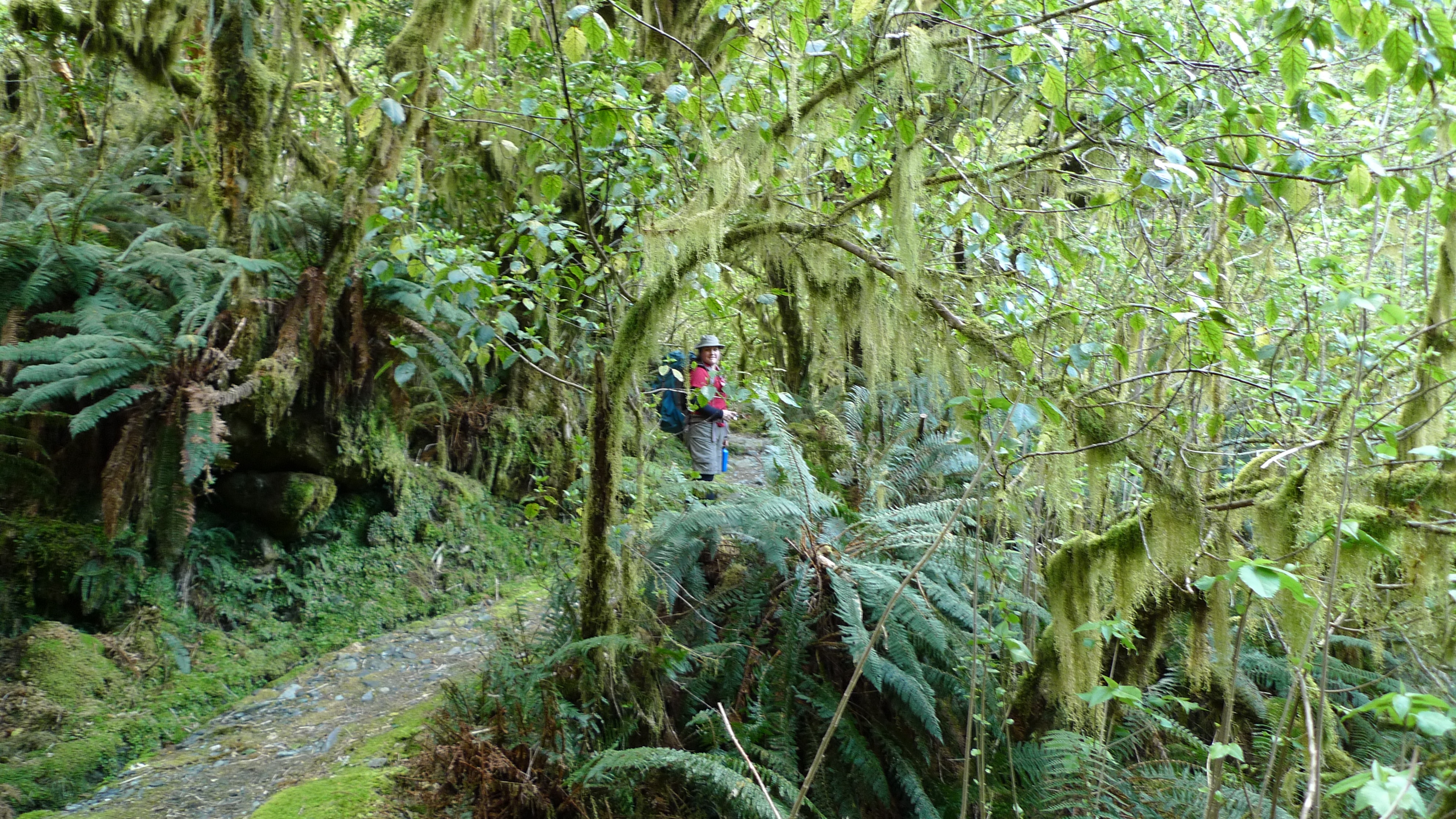
A wet forest
I was hoping to encounter snow/ice patches as we crossed the Pass. Even if we weren’t to be that lucky we knew it would very likely be cold up there, despite the fine start to the morning, as weather in alpine environments is notorious for changing extremely quickly. With those thoughts in mind we added long thermals underneath the shorts and t-shirts ensemble we wore yesterday – quite a fashion statement, I know, but not only does it work in keeping you warm, but out on the track no one cares what you look like (too much). Our jackets were also handy at the tops of our packs.
Looking back down Clinton Valley on another beautiful morning
Stunning, hey?
It wasn’t far to the next DOC hut where we stopped for morning tea, but we didn’t linger. It took a while to get to the start of the proper climb up and the 11 switchbacks.
Brief morning tea stop at Mintaro Hut – the second DOC hut for independent walkers
Almost at the switchback section – Stephen’s impatient to keep moving
I’m afraid I don’t have photos of what it was like on the switchbacks to share with you, incredible as that sounds. In our minds this was the challenge of the trip – the part that everyone talks about – the huge climb up to Mackinnon Pass. The part of the track that can turn into a waterfall when it rains heavily.
When it came to it, it wasn’t too hard… I think the start of Mt Warning (northern NSW, Australia) with all the steps is harder. Still, it was eyes down (due to the uneven surface) and legs moving as we kept up a steady pace (you might say a quick march!) and so caught up and passed a number of others (all labouring whilst trying to use their walking sticks in loose rocks!). I find keeping a steady pace is the key… too much stopping and starting is more wearying than staying in your rhythm and pushing on. Everyone’s different though – and the guides do stress that it is not a race.
Out of the forest, into the alpine section near the top of the pass
We weren’t far from the top when we caught up with the second guide who walked with us to the top. There were a couple of patches of snow before the top, but nothing much. Still, for a Queenslander, snow is snow! My wish had been granted. Stephen had his gaiters on, but I didn’t bother with mine, wanting maximum ventilation instead!
Looking back to Nicholas Cirque at the head of the valley and one of our guides
Woohoo! Snow! A wee bit, anyway. Mt Balloon rising up in the background.
There were a maybe half a dozen people there at Mackinnon’s monument before us. Claude (senior guide) pointed out the 12 second drop on the other side of the pass – the short (and terminal!) way down – from where we could also see our hut for the night (Quintin Lodge) and the old grass runway. Now that everything’s chopper’d in I don’t think it’s used anymore.
Stephen in front of Quintin Mackinnon’s Memorial with Mt Hart in the background
Standing next to Quintin Mackinnon’s Memorial with Nicholas Cirque in the background
Standing at the 12 second drop, looking down the other side of Mackinnon Pass to Quintin Lodge – this was taken with my standard (non-interchangeable) camera lens, not a fisheye or anything fancy. The airstrip points the way to Milford Sound.
Looking to the right from the 12sec drop, the track passes below Mt Balloon and down the gully (if you can call it that) between the mountains.
Pass Hut was still a short walk away, over a small hill that marks the highest point of the track. The weather was starting to close in from the west, but the view back down the valley were magnificent. They say the toilet there has the best view in the world, and I can vouch that, on a good day, they’re not far wrong!
Continuing on to the highest point of the pass. Mt Balloon rises before us.
Looking back to the Memorial and 12 sec drop lookout. Mt Hart to the left.
The landscape is BIG and can dwarf everything we do and achieve just by existing.
By the time we’d reached the sign marking the highest point of the pass – and the Milford Track – the weather was definitely changing
Altitude here is 1154m
We made it!! Looking back down the Clinton Valley – the way we’d come.
Pass Hut is designed just provide shelter from the weather during your lunch stop, not for camping in. It’s a long rectangular building divided in two: one side for independent walkers to use, the other side for the Ultimate Hikes group. Our side had a small kitchenette so that the guides can offer us a hot cup of soup or hot chocolate when we walked in. I don’t believe the other side had such luxuries. There are benches around the walls for everyone to park their rears – packs (and walking sticks) get dumped in the middle of the room.
Inside the hut; benches along the sides, and double entrance to keep out the weather. And two very nice DOC workers seeking a hot cuppa.
Despite the numerous steaming bodies at lunch quickly fogging up the windows, once we stopped walking it didn’t take too long to start feeling how cold it actually was.
After a big lunch, we shouldered our packs again and headed off. Stopping for just a few more quick photos…
Tutahuna / Common Vegetable Sheep (no, that’s not a typo – click here Raoulia eximia for an explanation)
Close-up of Tutahuna. Looks a little bit like coral to me.
Kopukapuka / Mt Cook Lilly (which is actually a member of the buttercup family)
This plant looks exactly like Pandani (Richea pandanifolia) which we are familiar with from around Cradle Mountain NP, but that species is found only in Tasmania (Australia). This is a Dracophyllum sp., possibly Dracophyllum fiordense, a related genus. (Ref)
Fiordland Mountain Daisy
We weren’t far from the hut when a chopper carrying a load at the end of a cable came up the valley in front of us and almost right over our heads! Seeing that load swinging pretty low in our direction was a bit frightening. It was possibly not as close as it felt, but we’d have been in trouble had the cable broken. It was bringing supplies packed in barrels to the two DOC workers who were working at the hut. The hut is brand new and they were finishing off the paths and garden area around the hut.
Chopper dropping off supplies for workers at Pass Hut
We continued on and down – a long way down. From the pass it’s 900m down to Quintin Lodge. If you ever have walked down the stairs of a high-rise building during a fire drill and thought that was a long walk and a bit hard on the knees, try multiplying it by however many times to get to 900m, take out the handrails, add in rain, backpacks and slippery stones and you’re nearly there. But the view on the track is infinitely better!
Another small bit of ice after lunch
Looking back to Mt Hart
A section near the top of the main track was closed due to avalanche danger from a nearby glacier, so we had to take the Emergency Track which leaves the main track after the 16 Mile post and meets up with it again before the 18 Mile post. Stephen managed to take a photo of every mile post on the way except for number 17, and the last one at the 33.5 mile mark at Sandfly Point which had a professional photographer there.
Main Track closed – instead of continuing across the hill, the Emergency Track heads pretty much straight down for a bit. Great use of a wheelbarrow.
The Emergency Track is steep and rough compared to the Main Track. Reminds me of a few tracks around Cradle Mountain.
Creative location for track indicator – but hey, it works!
Looking back up to Mackinnon Pass – probably about half way down in altitude but definitely not in kilometres (miles) to the lodge.
The descent wasn’t too hard, though I concede by the end even I was starting to feel my knees and hips – just a little. We didn’t dwadle, but took the time to be careful all the same. It had clouded over, and there were intermittent showers – we were lucky there wasn’t heavier rain. There were a couple of sections of boardwalk with plastic or chickenwire attached for grip – the guides had warned us that these sections can still be slippery and most accidents happen there because people subconsciously relax when walking on boards.
The first large waterfall we passed on the way down
I’m not sure why there were so few leaves on the the trees at the top of the forest. There was plenty of moss and ferns.
Crossed a few suspension bridges. Mt Hart in the background.
Lindsay Falls – possibly the lovliest we saw that day.
We were about half way or so down when we came to pass an older couple of independent walkers, who kindly moved to the side for us. I made a little slip just as we passed – I didn’t fall or anything – and made a comment that it doesn’t pay to be complacent. Just as we passed, the lady who was in front, demonstrated exactly why walking sticks can be hazardous. Seeing her next step could be tricky, she put her sticks on the smooth rock, took a step, the sticks slipped, and she was on her backside. Stephen helped her up and she was ok. It could have been worse – fortunately wasn’t – but walking sticks with metal points aren’t made for rocks. I wonder how many people in our group found that out in the same way.
An arching branch of ferns
Ferns on a tree
Lichen? on a tree
The track and bush around the last few km’s or so of the walk to the lodge felt very similar to Lamington National Park (Gold Coast hinterlands, Australia) – a well graded track of dirt and rocks with lush forest on either side. It was there that we heard the chopper flying in low again, and hurried over the last bridge to find ourselves at the end of the path and Quintin Lodge – finally! We were in time to get a few pics and see it fly off again. We were excited; I’m sure the staff were wondering what on earth for – hadn’t we seen helicopters before? Keep in mind they get flown to work in one – they really are a fly-in, fly-out work force!
A very busy helicopter!
The buildings that make up the Quintin Lodge complex are arranged in a square. Our room was again very nice, with a view overlooking the yard between the buildings with the mountains rising behind.
The view from our room at Quintin Lodge
Because today’s walk wasn’t nearly as long or hard as expected, we decided to do the optional side trip to Sutherland Falls which are the highest falls in New Zealand. The guides said that anyone who wanted to go should leave Quintin Lodge no later than 4.30pm as the walk takes ~1.5hrs (return). We had aimed to be at the lodge by 3pm, so would be back by the cut off time to start walking. We ran in (our entrance would have been at a more seemly pace if not for the chopper – although this isn’t our only walk that has ended at a run) to Quintin Lodge just after 2:30pm, which I guess means we more than made up for leaving 15min later than hoped that morning.
We dumped our packs and took only cameras, hats, and a water bottle and set off for the falls at about 2.45pm. We had been told to take rain coats/jackets too, but it had turned into a nice sunny afternoon and it didn’t look like it was going to rain. I figured it we got a bit of spray we’d dry out alright.
Donald Sutherland, who the falls are named after, was an explorer like Mackinnon but made his home where the Milford township now stands. He discovered the falls in 1880 while prospecting (unsuccessfully) for asbestos and brownite with John McKay (more about McKay in my next post; Milford Track Day 4). Later that decade the government paid him to cut an access track to Sutherland Falls; his track met up with Mackinnon’s track and together they make the Milford Track as we know it today. (Read more about Donald Sutherland here.)
Heading off to Sutherland Falls
At the start of the path the sign on the left says ‘Sutherland Falls 580m’ and the sign on the right says to allow 1hr 30min return. We thought “580m? No worries! We’ll be back in no time” and charged off at a good speed (now that we weren’t weighted down with packs). I couldn’t for the life of me think how 580m would take 45min…
We passed a few independents on their way back from the falls (they had a head start on our group this morning, but the DOC hut where they would stay the night was still a good few km’s further down the main track still); we were too focused on getting there to say more than ‘Hi’ as we passed – they probably wondered what the hell we were running from! We started to wonder… how long could 580m be?
It’s a lovely path – this is a little stream we crossed
We had slowed our pace from a jog to a brisk walk and were joking that maybe we had to climb 580m in elevation to get there when we came to an avalanche warning sign that said no stopping for 360m – we crossed that in minutes and by then it was rather obvious that 580m wasn’t how long the path was to the falls. A few minutes on we saw one of our party coming back along the track and he said we have about as far to go as the falls are high – and then we saw the sign saying exactly that; we were now 580m from the base of the falls – the same distance that they are high!! Important lesson that one – when you’re tired, you don’t think straight. We weren’t in any danger of getting lost on such a clear track and with a number of people around, but I see how easy it can be to get into trouble.
Human-sized fairy pathways through the forest
A Weka
Stephen spotted a Weka! Our second for the day – there was one up on Mackinnon Pass, too. They can fly but are predominantly terrestrial.
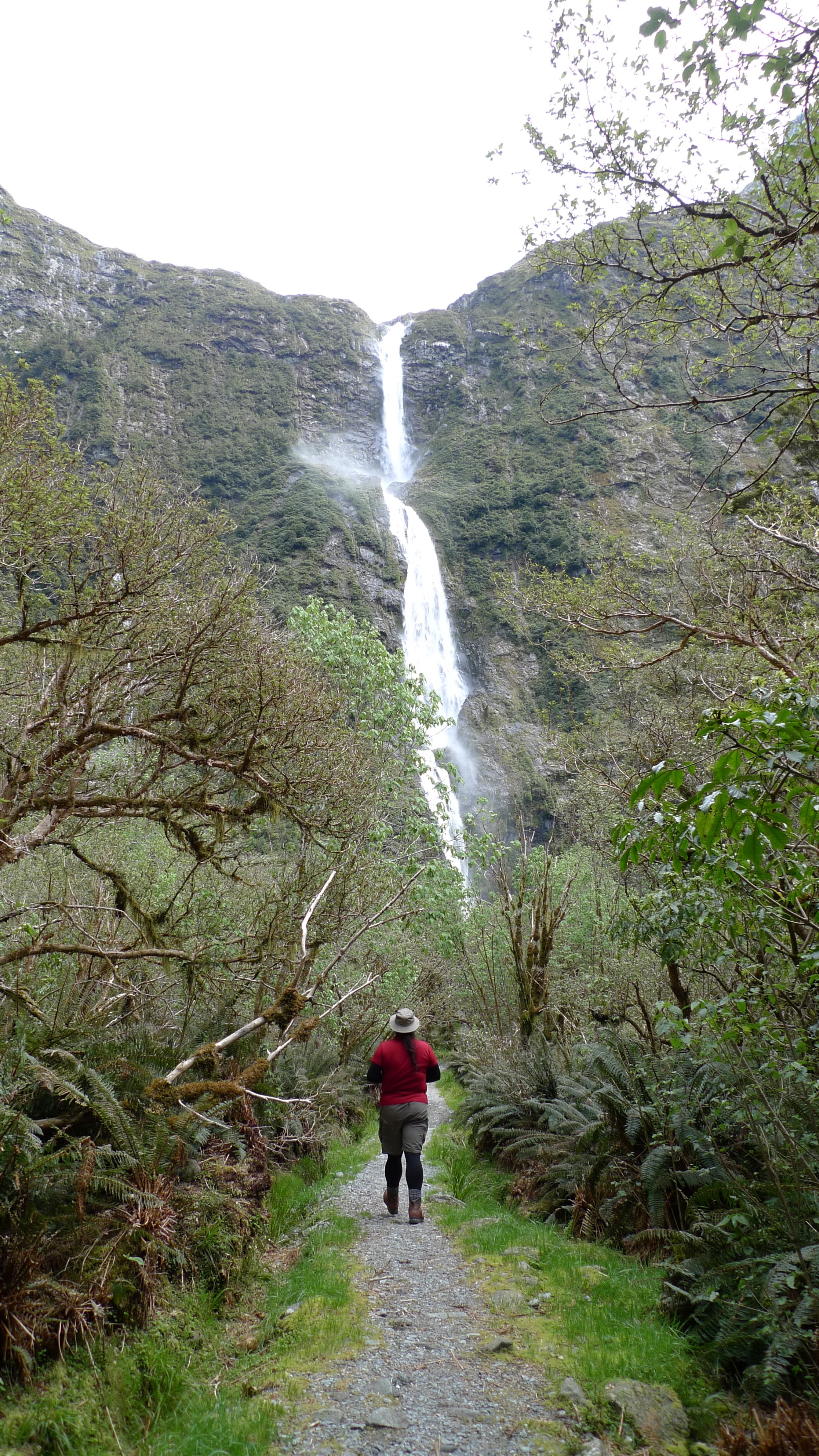
Approaching Sutherland Falls
The falls are very impressive, and the wind that the falling water creates at the base clearly explains the need for a raincoat. Despite a lot of spray we managed to take a few photos then turned back to return to the lodge.
Not a big pool, but the wind created by the falling water was quite strong
Sutherland Falls
Wide shot of Sutherland Falls
Damn it was good to finally take our boots off that night! Most people got to the lodge in time to take the walk to the falls. A few didn’t. One lady who was not a strong walker (around the hut she was fine, but as soon as she was on the track – sticks in hand – she walked like an invalid; very, very slowly and carefully, thinking about each step she took) didn’t get in until about 7pm – almost 12hours on the track. Just after lunch she’d fallen into a hole in the ice and had to wait 15min before the last guide came along to help her out! But she made it eventually. They do keep saying it’s not a race… On a previous trip a whole group didn’t make it to Quintin Lodge until 10.30pm! They were all flown to Mitre Peak Lodge the next day, since I guess they were all knackered and a group can’t stay more than one night in each hut – there’s up to another 50 guests a day behind ready to crash!
While that lady was probably in the worst shape of all of our group, she wasn’t the only one feeling relived today was over. Despite hiking boots being on the list of essential items, there was a couple on their honeymoon who were only wearing sneakers – and their feet were definitely talking to them! Most of the group were complaining about sore knees/legs/ankles. It really does pay to have good (broken-in) gear and to do some preparation before any hike of some length.
Our nightly powerpoint presentation reminded us that although Mackinnon Pass has been conquered, there was still a lot still to see (and walk!) on Day 4 on our way to Sandfly Point (the end of the Milford Track) and on to Mitre Peak Lodge.
Milford Sound. The jewel in the crown of Fiordland National Park, New Zealand. Renowned worldwide as a place of beauty and wonder.
Wilderness…waterfalls…wildlife…Mitre Peak…
You know – this place:
Mitre Peak; possibly the most photographed feature of Milford Sound… when it’s not hiding behind clouds. We were lucky this day!
If you haven’t been, chances are that you know someone who has, and they probably went for a cruise along the fiord to the ocean and back. No one goes just to stand on the pier and get eaten by sandflies… do they?
New Zealand Te Namu aka Blackflies (aka Sandflies or Midges).
But how many people have heard of about the Milford Track? Maybe not quite as many.
The Milford Track first crossed our radar while we were walking the Overland Track (in Tasmania). An older couple in our group had completed the 5 day walk with Ultimate Hikes and talked about their experience. It sounded pretty full-on! Whole groups (up to 50 guests) being moved from one camp to the next by helicopter because of obstructions on the track, and due to the next group following 1 day behind, you simply can not spend more than one night in the one location.
It wasn’t the prospect of a helicopter ride that appealed to me though. A few years prior I had toured New Zealand with my mum and I was keen to revisit Queenstown and Fiordland – actually, pretty much any part of New Zealand! Stephen had not been to New Zealand on holiday before, so it would be all new for him. We were both keen to find another multiday walk similar to that offered by Cradle Mountain Huts – Ultimate Hikes offers an option of double/queen-sized beds in addition to hot showers each night and someone else to cook your food – how can you pass that up?
Bedroom at Pompolona Lodge – Day 2 (it was neat when we arrived) – pretty flash compared to the public hut alternative
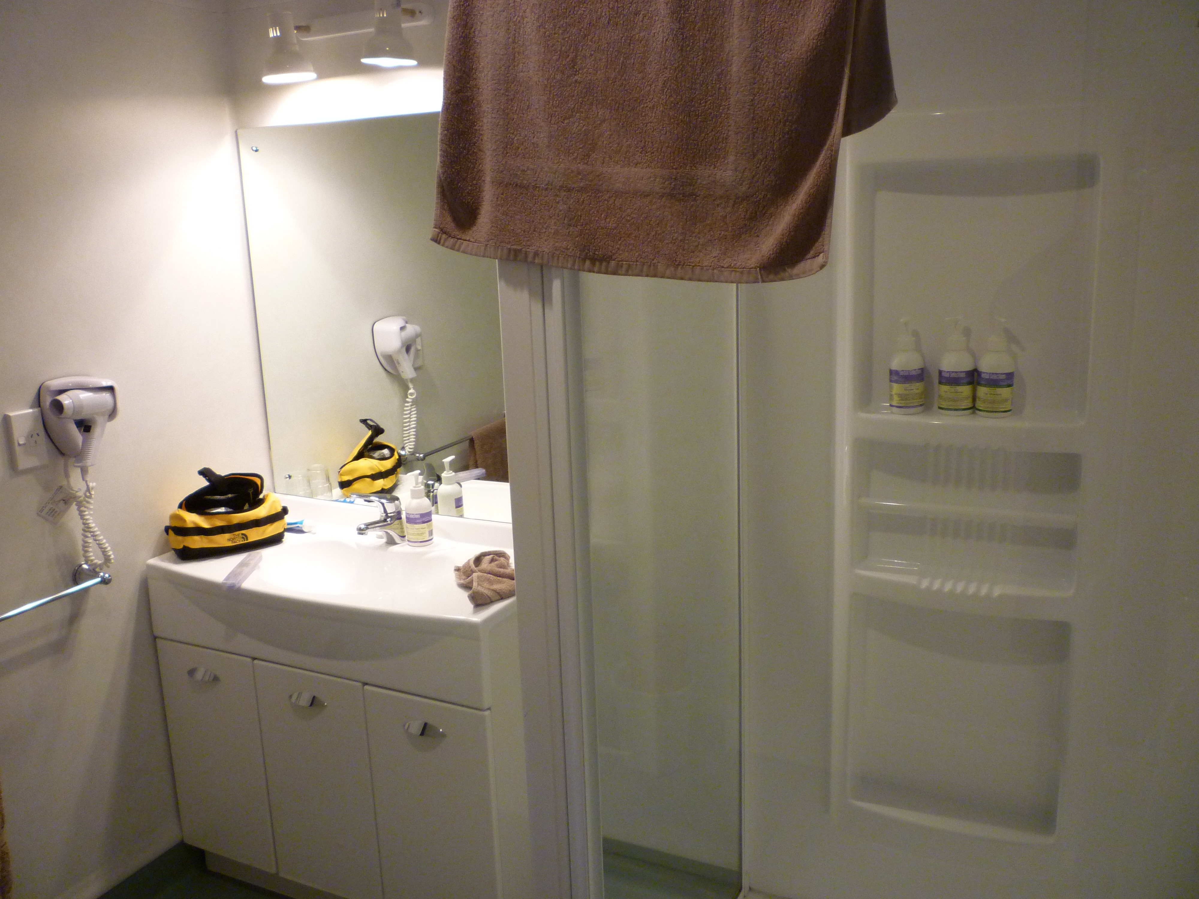
Ensuite at Pompolona Lodge – not bad considering you’re in the middle of a National Park in the remote and rugged wilderness
We did our research on Google and You Tube. Everyone raved about the scenery, but we also read about groups who came back with next to no photos because it was raining the whole time. We saw the groups wading through hip-dep water covering the path, following the trail-markers. We stared, eyebrows raised, at the videos of the tracks up the mountain turned into waterfalls that hikers were trying to climb. We therefore knew we must be resolved to getting more than just our feet wet on this walk!
We booked to go in November, when the track opens for the season and before things get extra wet in the summer, although it is highly likely to rain heavily throughout the year (that’s when it’s not snowing). They’re not kidding when they warn about the rainfall – they get 7 to 9metres per year! No point measuring downpours in millimetres over there.
The track is closed during winter due to snow, and in spring the Department of Conservation (DOC) clear the valleys the track passes through from risk of major avalanches by sound blasts or detonations. They also fly in (by chopper) the bridges that hikers will cross the streams and rivers on. There is a fair bit of preparation done for us hikers – or trampers, as Kiwis say.
The list of gear that Ultimate Hikes advises guests to bring is not long (Ultimate Hikes – Milford Track – What to Bring) – you don’t want to be carrying more than you need to – but essential for a ‘comfortable’ trek. We decided to take our own backpacks because they don’t get much use otherwise, and because they’d be doubling as our suitcases on the way home we’d need the extra room for our holiday purchases!
Not long before our departure date, our nice, convenient direct flight from Melbourne to Christchurch ended up being routed via Sydney. The only up side – if you can call it that – is that I can say I’ve departed Australia from three capital cities now. We arrived at midnight, got our hiking boots passed by customs – I think the guy was mildly impressed with how clean they were – and were asleep very shortly after getting to the motel, not far from the airport.
Christchurch to Queenstown
We were up bright and early for our flight to Queenstown. As I was checking out, Stephen saw a duck fly overhead which tilted both ways to look at him as it went. It became the standing joke of the trip that ducks in New Zealand say ‘queck queck’ instead of ‘quack quack’!
It’s a lovely flight to Queenstown, over the Canterbury Plains…
…don’t forget to appreciate their Braided River systems…
…and over the mountains…
…to descend into a valley…
…to one of the most scenic locations for airports I can imagine:
A plane with The Remarkables in the background
Inside Queenstown airport…
…and out the front.
We caught a cab to Brown’s Boutique Hotel – it has a fantastic Mediterranean feel to it (and it’s so close to home!), and since it’s in lovely location just up the hill from the main business area, the view is wonderful and it’s very convenient for shopping and dining, which we promptly went and did!
Brown’s Boutique Hotel with the Skyline Restaurant at the top of the hill in the background
View from our room at Brown’s of Queenstown and The Remarkables
Walking down to the main shopping area
Queenstown waterfront area
That afternoon we went on the Shotover Jet – no, not as part of a ‘combo’, which is an idea Kiwi’s seem to love with a passion (a bit like Tasmanians and buzzers*). Of course it was just as fun as I remembered it, and Stephen loved it too. We couldn’t have wished for a more beautiful afternoon, either.
Shotover River & bridge
Shotover Jet change station and boarding platforms
There was a pre-walk talk later that afternoon at the Ultimate Hikes office. Everyone gathered to meet our guides, and for a Power Point presentation overview of what each day of the walk would entail, as well as being talked through (as a final check) what we’d need to take – and what we wouldn’t need!
An overview of each day of the walk (and my following posts) are:
Day 1: Queenstown – Te Anau – Glade House (total walking 1 mile = 1.6km, plus an easy introductory forest walk after we arrived at Glad House and dumped our gear in our rooms)
Day 2: Glade House – Pompolona Lodge (10 miles = 16km) This was the easiest of the ‘proper’ walking days.
Day 3: Pompolona Lodge – Quintin Lodge via Mackinnon Pass (9 miles = 15km) I had thought going over the pass to be the most challenging day; it certainly was the most spectacular.
Day 4: Quintin Lodge to Mitre Peak Lodge via Sandfly Point (13miles = 21km) Despite being relatively flat, this was possibly the most challenging day, which was somewhat unexpected.
Day 5: Milford Sound Cruise, then back to Queenstown by bus (the finish post was passed yesterday).
A lot of emphasis seemed to be put on taking walking sticks, the selling point being that even the majority of guides wouldn’t walk without them! Stephen and I weren’t convinced and given that a) they weren’t a requirement and b) we managed the Overland Track fine without them, we were two of a very few number of people who didn’t bother to take at least one with us. They also had packs and other equipment available to borrow there for people who needed it.
Something good that they did have (that we haven’t found back home) is “Foot Fleece” – cleaned but otherwise unprocessed wool to put inside your socks where you’d be likely to get a blister. It works a treat and we picked up more from the DOC office (it’s a little cheaper there) when we got back from the walk to bring home with us. The DOC fleece is called “Trampers Friend”. It’s slightly coarser perhaps, but does just as great a job.
For dinner I had booked a Skyline combo (yes – a combo!) so we caught the gondola up the mountain to see their Kiwi Haka Show, and had dinner afterwards at their restaurant on top of the hill.
Queenstown from the Skyline complex
The show was much better than we had expected. Stephen volunteered to be Chief of our group (which involved accepting/passing their chief’s challenge) and later most of the ladies in the audience (myself included) got up to try using the ‘pompoms-on a string’, or “Poi”, that the Maori ladies use in their dancing. It was fun!
After the show
The view up there is spectacular (it is what you’re paying for, after all), and dinner (buffet) was also good.
It was an early-ish night because the next day would be an early enough start to Day 1 (of 5) of our Milford Track walk!
*Tasmanians and buzzers – if you’re not familiar with this reference, I promise I will write a post about it – please stay tuned.