Thanks to stretching adequately after the walk last night, climbing down from the top bunk wasn’t painful this morning, although an extra rung at the bottom of the ladder would have been helpful…
Another bottom rung wouldn’t have gone astray. It was a bit of a long step down in the morning.
Sunrise was beautiful. I might have been the only one out taking full advantage of it – I’m not 100% sure as I didn’t turn around to check, but I didn’t hear anyone else up and about.
Dawn’s glow on the clouds behind the Lighthouse
Glowing clouds in the east
The sun’s almost peaking through
Good morning Starshine!
Bright light along the veranda heralds a fabulous day
Yesterday we had arranged a lightstation tour for 10am today with Renata. Our tour started in the museum at the base of the lighthouse and heard how the lightstation used to also be a radar station during WWII. RAAF personnel were stationed on the point also; there are a number of photos from this time and physical remnants left on the point. The museum is open to the public.
This slideshow requires JavaScript.
After that we were allowed into the lighthouse! The lighthouse is still owned, operated and maintained by the Australian Maritime Safety Authority (AMSA) and public access is available only to groups under the supervision of a Park Ranger. At a height of only 19m (I think that’s to the beacon – the balcony is a couple of metres below) it’s not a big climb. Because the lighthouse sits atop granite cliffs the elevation above sea level is 117m, giving the beacon’s range 18 nautical miles (33km). Given the number of rocks and islands in this part of Bass Strait, the channel is reasonably narrow, and thus the lighthouse remains a very important visual navigation aid to sea-going vessels. There are also a couple of off-shore lights and lighthouses to help ships navigate Bass Strait.
The way is open – entering the lighthouse
The top platform beneath the lantern, which is as far as the public is allowed
Looking up to the light
How blue is the ocean!? I could gaze at it all day!
The top of the lighthouse from the platform
The buildings of Wilsons Promontory Lightstation from the top of the lighthouse
The bay to the west
Stephen & me
AMSA certificate for 150 years of service (lit 15 July 1859) & previous methods of illumination
Going down – the granite here is marvellous
Another perspective
Window in the lighthouse
Four lighthouse keepers and their families lived here, although the only original buildings left from that time are the cottage that we stayed in (Cottage #2) and the lighthouse itself. There was no road to the lightstation, so if anyone had to leave (e.g. for serious medical care) it was a long, hard journey back to civilisation – probably all the way back to Foster or Fish Creek. The township at Tidal River wasn’t constructed until 1946, and even the earlier camp at Darby River wasn’t established until the early 1900’s (when The Prom was given National Park status).
Read more about the details and history of the lighthouse here.
Renata also offered (and we accepted) a look in the other accommodation cottages available, as no one was in them at the time. Here’s a marked-up photo to help set the scene:
Note: the drinking tap I’ve highlighted on the centre path is provided primarily for day visitors. Overnight guests have the same fresh, filtered water from the convenience of taps in the cottages.
Parks Victoria Rangers Cottage (cottage #3) where you check in – if you’re not met at the top of the path like we were, after dragging yourself up the hill!
Parks Victoria Rangers Cottage & site of Victorian State School No 2278 for 6 months in 1880
The newly renovated Couples Cottage (Cottage #4) is amazing! Such a view to the west! And there’s a window facing east in the bedroom. How can they make you leave after just two nights? The additional charge to stay here also includes a queen size bed and linen – that’ll make the pack a bit lighter! Definitely choosing this option next time.
This slideshow requires JavaScript.
Cottage no 5 at the end of the row is another multi-share cottage. Colin was busy painting inside when we visited, so we didn’t go through every room. Less spacious than the old lighthouse keepers cottage that we were staying in, but comfortable and probably the coziest in winter.
This slideshow requires JavaScript.
Finally, Cottage No 2 – the original Lighthouse Keepers Cottage – our home away from home for the two nights we were lucky to be there.
This slideshow requires JavaScript.
And separately, the kitchen! Let there be no more surprises here – there is a refrigerator, microwave, microwavable containers in the cupboards, gas oven and stovetop, plenty of pots, pans, dishes, plates, utensils, chopping boards, glasses, mugs – and a spare food draw!
Kitchen cupboards, refrigerator, microwave, toaster, etc – and Stephen doing the dishes
Gas oven & stovetop
Pots, pans & baking trays
Kitchen draws – cutlery & utensils
Kitchen draws – Knives (not the sharpest), peelers & more utensils
Soon the first day visitors had arrived. Without packs, not wearing what I’d call hiking gear, and carrying only disposable (thin plastic) drink bottles. We were somewhat surprised by their attire. It’s as though they weren’t miles from anywhere, but at a local park.
Renata said they average 30-40 day visitors per day (a significant flaw in an otherwise perfect location – the presence of other people). Sure, the lighthouse may only be an interesting side trip for most people walking between Waterloo Bay and Roaring Meg camp sites, but surely that only explains the lack of backpacks?
Day visitors to the lighthouse – people hike like this?
If one of these young blokes (or girls, but the majority were young blokes) dropped their plastic water bottle and it broke, he’d better hope he could reply on a friend to share water with him until the next stop. They mightn’t be walking 25km in one go like we were, but if it was a hot day like yesterday, being one bottle down (assuming they had more than one) was a serious blow all the same. The owners of Black Cockatoo Cottages told us they hadn’t had rain this year, and the park at the end of summer was definitely looking dry. We were carrying water purification tablets, but I doubt these kids were, or had anything similar, and it’s not safe to drink the water straight from the creeks.
Don’t get me started on their shoes!
When the lightstation was first built back in the 1850’s, equipment and supplies were brought in by boat every six months. A flying fox was set up from a site just below the hill known as the ‘eastern landing’ to the top of the point, because even just lugging yourself up the hill in those days must have been much more of a challenge – there wasn’t a nice concrete path back then! There was a western landing used at one time too, but the eastern side proved better (probably more sheltered from the prevailing winds). Offloading cargo from either side was tricky business at the best of times.
After lunch we decided to brave the steep path once again to see the eastern landing.
There used to be a flying fox to haul supplies up the hill from the dock at east landing
The remnants of the flying fox and the east bay where the supplies were brought in
Walking down the hill is easier than walking up was yesterday (hmmm, no surprise there), but I was very glad that we weren’t wearing back packs today.
The path down the hill from the lightstation. It is every bit as steep as it looks and possibly more.
We continue straight on to the East Landing, instead of turning off to the path on the left we came in on
There’s no beach or convenient looking place for a swim – something that used to torment the early lighthouse keepers during hot summer days. I think Renata said seals are sometimes seen on the rocks. The deep, clear water and healthy kelp attached to the rocks looks like great seal habitat.
Nice big hazard warning signs, but you couldn’t wish for better conditions than what we enjoyed
Eastern Landing!
These granite slabs are huge and beautiful
It’s so similar to northern and eastern Tasmania – we are so close here, so it’s not that surprising
I did’t even see the steps until after… to busy having fun climbing around the rocks!
The blue, blue sea. I wasn’t thinking of a swim… more along the lines of seals and sharks?
A deep circular pool full of life that scuttled into the depths when I approached
There were quite a few crabs in crevices. “Don’t look!” one might be saying to the other
Some of the marine life in the circular rock pool
A silver gull
Looking back up the hill at the lightstation
The platform where the crane to help unload the boats would have been bolted
A blue-tongue lizard sunning itself on the path
The oranged rocks are so reminiscent of the north and eastern coast of Tasmania – which is not very far away, so it’s hardly a surprise.
We discovered that walking up the hill isn’t half as bad when you’re refreshed and not carrying a heavy pack. Still very steep though.
The rest of the afternoon was passed lounging around drinking wine (trying to finish it so we didn’t have to carry it out), eating cheese (trying to finish it so we didn’t have to carry it out), then taking a stroll around the place to walk off the wine and cheese before dinner.
Enjoying wine and cheese on the veranda
Information on the Bureau of Meterology’s weather station at the lightstation
White-bellied Sea-eagle (Haliaeetus leucogaster)
Swamp Wallaby (Wallabia bicolor)
The swamp wallabies and wombats do well at keeping down the grass
Swampies camouflage very well
I saw a juvenile White-bellied Sea-eagle too, but without significantly more zoom than what currently I’ve got I can’t show you a decent photo, so you’re just going to have to take my word for it. I was pretty chuffed when I realised what I had seen.
Other hikers planning to stay had arrived and that night not only was our cottage full (sleeping 10 in 4 rooms) but people had arrived to stay at the couple’s cottage next to the rangers cottage. I bet they wished they had come for more than one night! (Neal and Elle reported that you can’t book accommodation at the lightstation for a Thursday night).
Sunset was in a gorgeous purple theme…
Dusk at Wilsons Promontory Lightstation
Sunset colours the clouds at Wilsons Promontory Lightstation
It’s too beautiful an evening to be inside
Wilsons Prom Lighthouse and Rodondo Island
Sunset from the corner garden
Purple hued sunset
Unlike the previous night when it (actually!) rained, tonight was clear and had the bonus of a more-than-half-full waxing moon. After dinner we grabbed torches and cameras and went out.
The wombat and baby had already been spotted earlier (in the back garden) but heading to the top of the path we again disturbed the pair of swamp wallabies as we took photos of the moonlight on the eastern bay.
The moon shines brightly on a calm ocean
Torches not required with a moon this bright
Approaching it’s 155th anniversary, the lighthouse shines on
The lightstation at night
You can just make out the mother wombat & young near the light in the garden
A glowing beacon in the velvety night
The lighthouse and cottages at Wilsons Promontory National Park Lightstation
Stephen noticed he didn’t really need his torch to find wombats – he could hear them chewing as he was positioning his camera to photograph something else! They’re noisy enough when they’re only about a metre away. I guess you should carry a torch to make sure you don’t trip over one?!
Wombat munching away
I was watching two in the garden outside the rangers cottage when something startled one. There was a rustle, then in a split second they were both gone! It’s amazing how fast they can move! They must have both been not much further than a metre or two from a burrow entrance.
Last August we left Wilsons Promontory Nation Park (aka “The Prom”) with a sense of frustration that we couldn’t explore very much of the park in one-day-return walks. This had to be amended.
There are two multi-day circuits you can walk in the park – northern and southern – that have campsites spaced at reasonable distances along the way. I’ve read that the southern circuit is the more popular, easier and better defined of the two. The southern circuit also includes optional side walks to mainland Australia’s most south-eastern point and most southerly point; both of which we hoped to bag on this trip.
With the added lure of being able to stay at the lightstation at the south-eastern corner, a mere 20km (roughly) from Tidal River, plans were made to return. It would mean at least two days of long walks to get there and back, but if that’s what it was going to take, then so be it. As mentioned in my previous post we aren’t equipped for camping which is why this would be an all-or-nothing dash between Tidal River and the Lightstation (and back again). If we were also camping we’d probably do it as a 4 or 5 night walk, and travel only half the distance each day that we did.
Our Destination – Wilsons Promontory Lightstation
In preparing for the walk we found there to be a lack of detailed information about both the walk and the accommodation at the lightstation from Parks Victoria – or maybe the information provided is of usual standard and we were just nervous first-timers. I’m not sure.
In any case, we already had an SV Map from our previous visit (see August 2013 Part 1 & Part 2) which, while not quite pocket size, actually gives you the type of information that is of greatest benefit when preparing for walks; trivial details like contour lines, distances between points, landmarks etc – the kind of details you don’t get on Parks Victoria’s maps. Perusing photos shared on Google Maps will convince you that taking your camera along is a good idea (if you weren’t already planning to do so), but likewise doesn’t greatly assist in giving you much of an idea of what to expect along the way.
For the accommodation side of things, the greatest insight (and a large part of the inspiration) was provided by Greg of Hiking Fiasco fame who visited the lighthouse back in 2009. (Note: his photos are from Cottage 5 which currently sleeps about 10 people.) It was this post of Greg’s that lead me to embark on creating our own menu of hiking food – see previous post.
Therefore, our goals for this expedition were twofold:
1. to make it to the lighthouse & return again safely
2. to take enough photos to support a detailed blog post to help anyone else planning to walk to the lighthouse for the first time get a better idea of what to expect
Day 1: Tidal River to Wilsons Promontory Lighthouse (South East Lightstation) via Oberon Bay Walking Track then Telegraph Track
Our route to Wilsons Promontory Lighthouse
Having driven down from Melbourne the day before, Black Cockatoo’s studio cottage (just oust side the park in Yanakie) was ‘base camp’, allowing us to enjoy a good night’s sleep before rising early and excited, ready for our first big day of walking.
You can’t pass up the opportunity to take a few photos of the sunrise when it presents itself like this, though.
This slideshow requires JavaScript.
We’d weighed our packs before leaving home. Despite last minute culling of one or two more items that morning, with the addition of our water bottles mine would have weighed 16.5kg or so and Stephen’s was about 18kg. Ooof!
It was a quiet drive down to Tidal River; not too many people on the road, and no wildlife either. There’s no point being too early, as the Visitor Centre doesn’t open until 8:30am. We arrived at about 8:45am, presented ourselves with booking confirmation at the main desk and were given a sticker to display inside the car’s windscreen. Despite the Parks Victoria website suggesting that we’d need to collect a permit (each?):
…nothing was given or mentioned. We were asked to check in again on our way out – and then we were free to go! I asked if there were any track issues we should be aware of, but apparently there are none at present.
By the time we put our boots on, packed up the car and made a last comfort stop it was 9:15am. Well and truly time to head off.
Look – people! (There were very few last August)
Caught unawares, looking happy, about to set off
Note: The shortest path to the lighthouse is to drive to the top of Telegraph Saddle (Oberon) Carpark, leave your car there (only Parks Victoria vehicles are allowed further), and follow Telegraph Track the whole way down. The shortest possible route (per our SV Map) indicated that to be 17.9km. We did not chose this option because:
(1) Stephen had read comments suggesting that it is less safe to leave your car up at the saddle carpark (and we like the Mini just as it is) so parking it right outside the Visitor Centre & police station (though we’ve never seen signs of police actually there – possibly it’s a peak season thing) seemed like the safest choice; and
(2) We’d read that the Telegraph Saddle Track is a bit boring, so walking the whole length in one go was not too appealing. The original plan was to return on Day 3 from the lighthouse via the South East Walking Track, taking the Waterloo Bay Walking Track back to Telegraph Junction, return to Tidal River over the Telegraph Saddle and see what we’d missed out on (but with lighter packs by then).
By choosing to leave the car at Tidal River, we then had the options of two routes to get to Telegraph Junction:
– either by taking the undulating and varied Oberon Bay Walking Track around the west coast to Oberon Bay
– or heading inland and walking up and over Telegraph Saddle to follow Telegraph track the whole way.
The Oberon Bay Walking track option is 1.4km longer, but on the other hand you avoid a climb of approx 200m (with full and heavy packs) at the outset. We chose Oberon Bay Walking Track.
Note that there is a shuttle bus service up to Telegraph Saddle but it doesn’t operate during the week, only during peak periods when the Telegraph Saddle (Oberon) carpark is otherwise closed to private cars (see more about the shuttle bus service here).
Thus, this was the elevation profile for our walk to the lightstation:
Elevation profile to Wilsons Prmontory Lighthouse
Oberon Bay Walking Track (very glamorously) starts behind the toilet block between the Visitor Centre and the General Store at Tidal River. This path is well formed and well travelled, and provides lovely beach views as it climbs up to Norman Point and around to Little Oberon Bay.
(I have added in a couple of track photos from August – just convince you that it’s not all calm conditions and sunshine there!)
This slideshow requires JavaScript.
There’s a short stretch of beach to cross at Little Oberon Bay. (What a beautiful place this is!)
Little Oberon Bay
White sand at Little Oberon Bay
On the beach at Little Oberon Bay
Just after you cross the line of rocks bisecting the beach, look for a mass of footprints that leads up to the shelf above the beach. There’s a yellow sign indicating where the track continues on.
And that’s not the trickiest one in the park by a long shot. Here’s a closer photo so you know what you’re looking for, not just roughly where.
This is a very well beaten path, still being within pretty easy walking distance of Tidal River, but if the weather has wiped out the dozens of footprints usually there to follow, look for the line of rocks indicating the path.
The track around the next headland is very similar to the one around Norman Point. It was along here that I was intrigued to see, and count myself lucky to have got the chance to photograph, a white-lipped snake.
White-lipped snake on path to Oberon Bay
Close up of the head of the white-lipped snake
My copy of “Australian Reptiles and Amphibians” (Leonard Cronin, 2001) advises that the White-lipped Snake (Drysdalia coronoides) is venomous but not dangerous. Although they may grow to 50cm long, this one was only about 20cm, I’d say. And if you’re wondering what they eat…
…skinks, skink eggs, frogs and even small mammals are all potential prey.
By now Oberon Beach was in sight. We’d checked ahead and knew the tide would be pretty low when we got to Growler Creek, meaning getting wet feet was highly unlikely. Keep in mind too, that there hasn’t been any rain (or meaningful rain) for the last couple of months.
Oberon Bay
Descending to Growler Creek
The start of the path around the headland back to Little Oberon Bay from Growler Creek
Starting off along Oberon Beach
Stephen crossing Growler Creek
We hadn’t walked along Oberon Beach before, so weren’t exactly sure where the turn off was. I thought it was at the end of the beach, but was hoping for another bright yellow sign to show the way. So we kept walking, taking photos and looking for a bright yellow sign…
Growler Creek from Oberon Beach
Great Glennie Island from Oberon Beach
Immature (2nd yr) Pacific Gull
It’s easy walking along the flat wet sand of Oberon Beach
Crested Tern (non-breeding)
Looking back across Oberon Bay to Norman Point
Too busy walking to the end of the beach & photographing birds, I missed this sign
I was slightly wrong. We overshot by a couple of hundred metres. The track to/from the beach is on the northern side of Fraser Creek, and indicated by the usual wooden green Vic Parks sign but it’s not accompanied by a yellow high-visibilty-type sign that we were looking for. Which is why I’ve adulterated this next photo, in the hope that it may help someone else avoid our mistake. Frasers Creek is only about 1km along from Growler Creek, and you should look for the signed path through the low dune just north of Frasers Creek, which itself is pretty obvious.
The sign marking the path to Oberon campsite & Telegraph Track
The path through the dune behind Oberon Bay
After about 30m there is a nice new composting toilet at the turn off to the camping ground. The track to Telegraph Track continues for 3.5km eastward on a pretty sandy, mildly undulating, vehicle track.
Nice loo! Path to Telegraph Track to the left, path to campsite to the right
It was getting noticeably warm by this point. There wasn’t a lot of breeze today, and walking through the valley floor I was wondering how stifling it could get through here in the height of summer (usually mid January to the end of February)…
This slideshow requires JavaScript.
We finally made it to Telegraph Junction. It felt like a long 11km from Tidal River. Mind you, I couldn’t get my back pack to settle comfortably, and the day really seemed to be hotter than the predicted 23oC, which wasn’t helping.
Looking back along Oberon Bay Walking Track (the way we’d come)
The sign on the opposite side of Telegraph Track where Oberon Bay Walking Track starts/ends
There is probably about 30m (max) between where the Oberon Bay Walking Track meets the Telegraph Track from the west and where the Waterloo Bay Track meets up from the east. This area is known as Telegraph Junction.
Telegraph Junction – About 30m ahead where the clump of trees shades the road is the turnoff to Lt Waterloo Bay
Waterloo Bay Walking Track & Telegraph Track junction
Telegraph Track is (currently) a very well made and maintained maintenance road running from Telegraph Saddle (Oberon Carpark) to about 3km from the lightstation. The park rangers at the lighthouse drive this road to start/finish their weekly shift. It makes for sure footing, but it’s also pretty hot and exposed.
The long slog up over the southern hills begins – Telegraph Track
An old telegraph pole on the side of Telegraph Track
Soon every metre of shade counts as the road reflects the heat back up at us – Telegraph Track
Just 1.8km along from Telegraph Junction, but already feeling like a fair way higher up the hill, Halfway Hut was a great location for a brief lunch stop just off the side of the road (there is also a camping area nearby).
Turnoff to Halfway Hut from Telegraph Track, heading south towards Roaring Meg/Lightstation
Halfway Hut
Inside Halfway Hut
Toilet near Halfway Hut – Telegraph Track
Turn off to Halfway Hut from Telegraph Track, heading north towards Tidal River
The further we walked, the more I was convinced that it was hotter than 23oC – Stephen later found out from one of the park rangers that it got up to 30oC. But knowing that at the time wouldn’t have helped. You have to be mindful of how much you’re drinking and just keep putting one foot in front of the other.
But damn it was a long, hard slog up that road on the slopes of Telegraph Hill and past Martins Hill!
This slideshow requires JavaScript.
After many false summits we were finally at the top of the track by Martins Hill. The vegetation’s quite cleared up there as it’s also a helicopter landing area (according to our map). I didn’t feel the relief though. All I could think about was drinking long glasses of lemon effervescent drink (currently in powder form in my pack) once we finally made it to the lightstation – still a long way off – and meanwhile my pack wasn’t getting any lighter.
Walking track option to Roaring Meg campsite from Telegraph Track at top of Martin’s Hill
Here at the top of the hill is the start/end of an alternative walking track route that is 200m longer than the management track. We decided to stick with the vehicle track thinking it’d be a better grade and possible quicker. (Much earlier in the walk, when we were heading up to Norman Point, Stephen had an small accident that resulted in a skinned knee. This influenced a couple of track choice decisions.)
I’d like to say I took the opportunity to enjoy walking downhill for a while, but I confess the main thought on my mind was, ‘If we come back up this road [i.e. taking the shortest way back, which seemed more than likely at this point] it’s going to be another looong slog.”
This slideshow requires JavaScript.
The tall trees and ferns in the gullies here are lovely, and in any other circumstance I’d probably have been delighted to be walking there, but under the circumstances I didn’t appreciate it as fully as it possibly deserved. The shady parts were wonderful, but surely all this downhill walking meant that soon we would see some sign that we were getting close to the end of the promontory? Unfortunately, there is no glimpse or even hint of your goal (or even the ocean) until you’re practically upon it, and that’s not for half a dozen kilometres yet. There’s nothing but the neighboring hills.
Probably less than 100m before you get to Roaring Meg Creek at the bottom of the hill is an intersection that I shall refer to as ‘Roaring Meg Junction’. Here is the turnoff to Roaring Meg campsite and also the track to South Point, the inventively named most southerly point on the Australian mainland – a destination I had originally hoped to bag the following day, but one that was looking increasingly unlikely (this trip). It’s also at this junction that the bushwalking track that we could have taken back up at the top near Martins Hill joins back to the management track. Another bushwalking track option starts – this time it’s 1.1km shorter (2.3km vs 3.4km) to head off the road. The bushwalking track re-joins the management track 3.8km before the lightstation (per our SV Map).
Roaring Meg junction – Telegraph Track
Sign at Roaring Meg junction – Telegraph Track
It was at Roaring Meg Junction that we first met Neal (possibly Neil) and Elle (possibly El). They were also heading to the lighthouse but had chosen the shorter option of starting from Telegraph Saddle and had taken the bushwalker track from Martin’s Hill to this point.
We decided to continue on along the management track, and they chose the bush track. I was not over the moon with this decision, thinking that any track in the shade had to be 100x better than one with bugger-all shade and more hot, gravel surface reflecting the heat back up at me (keeping in mind it was 30oC, with out much in the way of a breeze for the most part), but it was the even surface that Stephen wanted (due to his knee).
It was slow going up along there.
This slideshow requires JavaScript.
One surprise on the way up that long rise was something every bushwalker should be mindful of, especially on warm days – a snake!
It was startled by Stephen who was a few metres ahead of me. A dark Tiger Snake (see also), a good metre or so in length, neck flattened, gave me a warning look and quickly moved off the road. “Holy Shit!!” was my startled exclamation.
Tiger snake disappearing into the scrub
A kilometre or so further along was anotherTiger Snake (Notechis scutatus). Stephen, still walking in front, was the one to startle it, but this time saw it out of the corner of his eye and got a bit of a fright himself! I don’t think the snake saw me at first. It was lying across the road and watching Stephen.
My photo of the snake, looking at Stephen who’d just walked past
Then it noticed me approaching!
I wasn’t sure how to pass. Not in front! Behind?
More effective than Gandalf in barring the way
It took a few seconds (and given my dehydrated state, that’s not surprising) but I realised it wasn’t moving off like the first one did because it felt threatened – trapped between two giant (potential) predators it didn’t know what to do. The flattened neck was a bit of a give away. Once Stephen and I both backed off a few metres (it didn’t take much) the snake relaxed and within 15sec you’d have never known there was a snake there at all.
In the Visitor Centre back at Tidal River there is a sign warning that there are various species of snake in the park. I took this photo on our first trip to the park last August (of course, being winter we were much less likely to see a snake then).
Parks Victoria notice – Snakes in the Park
Thank goodness both the Tiger Snakes we passed were only interested in disappearing into the bush. I had a couple of compression bandages once, but they got old and mouldy and haven’t been replaced. Our first aid kit has one standard length cotton stretch (crepe) bandage. We may have to do something about that. I had recently heard that the recommended treatment for snakebite had changed… I’ve now looked it up – here’s a link to St John Ambulance’s advice – which is pretty much as I remember it.
Looking back at where the walking track joins back up with Telegraph Track
Neal and Elle told us later that although the bushwalking track is shorter, because it’s so steep (and small stones on the path make steep slopes sometimes feel like you’re walking on marbles) it’s not really the easier option.
At last you start heading downhill again and finally come to a couple of signs. The usual green-painted Parks Victoria sign with the hopeless blobby arrows on the right-hand side of the road indicates that the small dirt path on the left side of the road is the southern end of the South East Walking Track. A sign just ahead (on the left-hand side of the road) saying “No Through Road” convinced me that although the track off to the side looked like a goat track, it could actually be legitimate. I’m pretty sure the Parks Victoria sign didn’t say anything about the lightstation, but I failed to take a photo to check! Someone had helpfully scratched into the dirt of the road “Girls this way” with an arrow pointing to the small side track… With that ambiguous statement to ponder, we set off along what I really hoped would turn out to be the right path. Thankfully it was.
This slideshow requires JavaScript.
Finally you get to see your destination! It’s a fair way down from Telegraph Track.
Our destination – Wilsons Promontory Lightstation
Getting closer! – Wilsons Promontory Lightstation
The bay to the west of the lightstation on a very calm afternoon, Rodondo Island (Tas) in the distance
From this angle, the hill in between and the final climb don’t look too bad…
At one of the turns, most of the way down, is the turn off from the South East Walking Track to the lighthouse.
Turn off to the lighthouse – less than 1km to go, but it’s pretty steep going
If the small hill between you and the South East Point was man-made, then I would say it was a cruel joke. It’s steep, although (thankfully) reasonably short. There are also unmarked graves near the large ‘skull rocks’ near the top – they once had wooden markers, but they were destroyed in one of the bushfires that burnt out the promontory – the massive bushfire of 1951 I think we were told.
That hill looks fun
It’s every bit as steep as it looks and more
Approaching ‘Skull Rocks’
Close-up of the weathered granite rocks
Just over the hill with the skull rocks is the helipad where supplies are flown in a few times a year. We saw Neal and Elle ahead of us, already walking up the last steep path to the lightstation.
Helipad servicing the lightstation
You can just see Elle wearing a red backpack climbing the hill ahead
Unlike many visitors (it seems), we had been forewarned about this bit, thanks to Hiking Fiasco. Knowing it was coming certainly helped mentally prepare for it, but it was even steeper than I’d given his story credit.
Here we were. Time to face the Big Climb To The Top
One…last…effort.
I confess I was thinking of Frodo & Sam on Mt Doom
And then there was Renata, one of the Park Rangers welcoming me to the top, and Stephen with a freshly filled bottle of cold water (I had a mouthful but I was still hanging out for that effervescent drink).
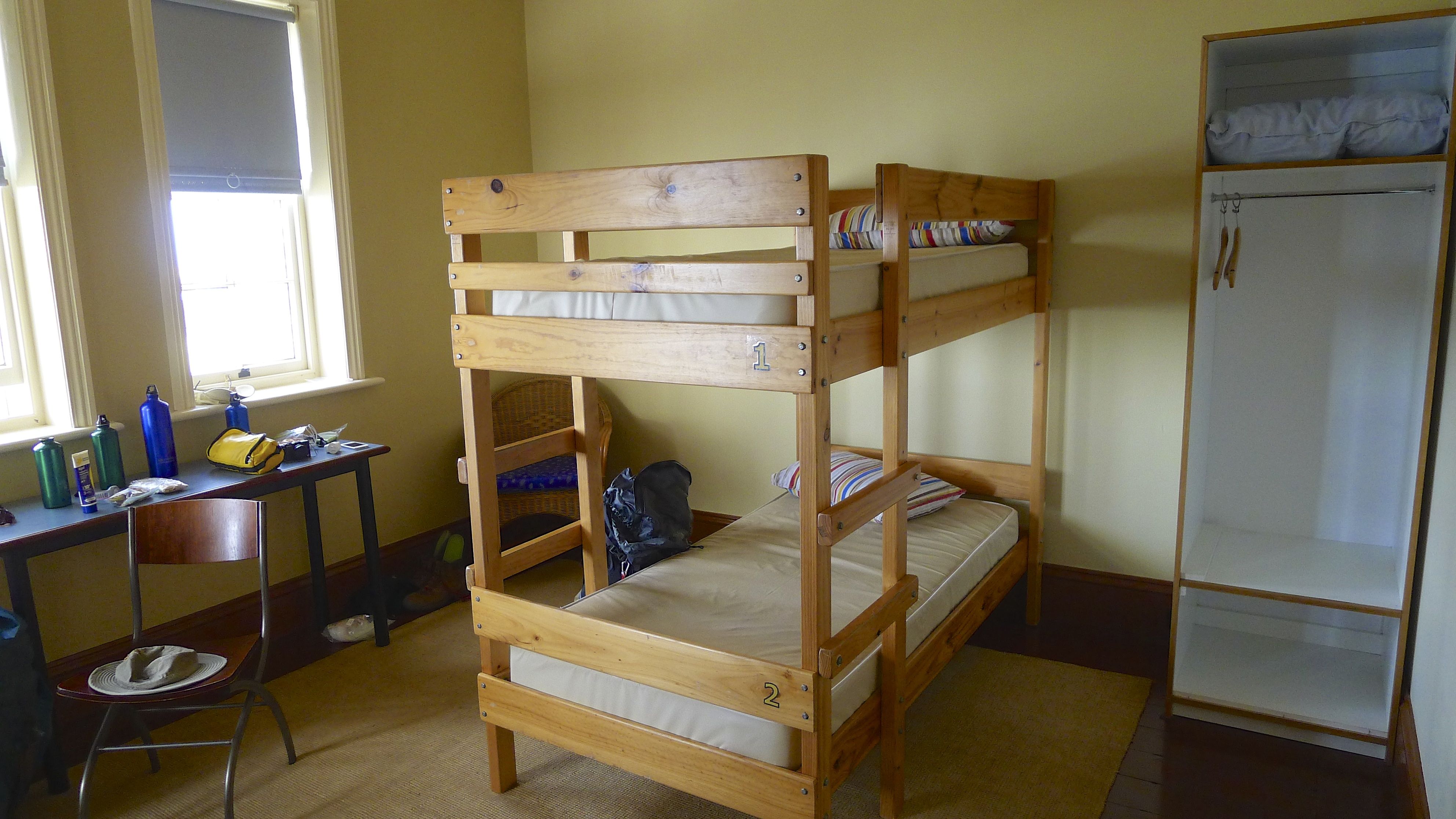
We were shown around the old Lighthouse Keepers Cottage and met Colin, the other Park Ranger stationed here this week. We had room No 1 (perhaps because we were the first to book?) which is possibly the best, as it has it’s own door to the veranda and you can look directly out to the lighthouse (but the light doesn’t shine in of a nighttime). Finally we could drop our bags, take off the boots, find my bag of powdered saline drink and gulp down as much of the replenishing lemon-flavoured drink as I needed to feel somewhat recovered again. (Tip: you know you’ve had enough when it starts to taste less appealing.)
Once we’d rested for a few minutes, it was time for a wonderful hot shower, clean clothes, then to explore! (With a bottle of water in hand; re-hydrating properly can take a while.)
Our room had it’s own door to the veranda which was pretty special
The eastern side of the veranda
Wilsons Promontory Lighthouse aka South East Point Lighthouse & Bureau of Meteorology (BoM) weather station, Rodondo Is (TAS) in the background
The main entrance of the Lighthouse Keepers Cottage (left) and the Parks Victoria Keepers cottage (right)
Looking down the main path to the lighthouse
‘Tis the season for Bare Naked Ladies to pop up… I think they’re heritage protected while they stay in the gardens (which they haven’t)
Looking north along the east coast toward Waterloo Bay
There used to be a flying fox to haul supplies up the hill from the dock at east landing
Behind the cottages on the west side of the path
Day visitors don’t get much, but on the whole they don’t come for long and I don’t think they come for comfort
The Lighthouse Keepers Cottage
Truly, it wasn’t long before the pure bliss of being here totally washed away all the negative sentiments thought along the Telegraph Track. And then some.
Forty Foot Rock and Mancoeur Islands (I think) – just some of the more obvious reasons for the lighthouse
The bay to the west of the lightstation
Looking out to Rodondo Island, which falls under Tasmania’s jurisdiction
Standing atop my favourite rock, behind Cottage 5
You can see all the way to South Point from here I think, just don’t go past this point
A ship heading to Melbourne
Great moody clouds over the ocean
It’s so peaceful and relaxing here… but I’m not sure how often it’s this calm.
I quickly decided I could happily live here. It’s not just because the walk back out seemed like a lot of effort (especially right now, having just walked 25km to get here), but because it was just perfect. Nice breeze, tall cliffs, lighthouse, ocean, offshore islands, tall, forested mountains, hardly anyone around – what more could you possibly ask?
How about seeing a wombat and her baby walking around the cottages? Well, we did.
A wombat and her young
Stephen’s very cleverly put together this collage of them.
Apparently there are about 12 that live around the cottages, and given the amount of wombat poo around, that’s not hard to believe! They do very well at keeping the grass down. They’re quite a bit darker than the ones that live around Tidal River.
Wombat at Tidal River – much lighter coloured than those seen at the lightstation
It turned out that it was only the four of us staying at the cottage that night – Stephen and I, and Neal and Elle. It was a nice and companionable evening. (I hope we didn’t bang on at them too much about our opinions on how visitor options for the park could be seriously improved.)
It rained that evening and into the night (which was great to hear) so we didn’t go spotlighting or take any starry photos. I just hope the rain was wide spread in the region as it’s desperately wanted.
“A maximum two night stay applies to Lightstation accommodation” is first in Victoria Park’s list of Things To Remember when planning a trip to Wilsons Promontory Lighthouse. (They also helpfully point out that there is no minimum stay.)
Wilsons Promontory Lighthouse – photo taken prior to 1942 (not sure who by)
Fortunately for us there is accommodation available otherwise we might not get to the lighthouse. To date we haven’t included camping with our hiking expeditions. Our multi-day hikes have all been with guiding companies who take away the worry of accommodation and food; you just have to bring clothes, minimal toiletries and walk from A to B.
Our desire to see the lighthouse at the most south-easterly point of mainland Australia has prompted us to take the next step in self-sufficiency.
Wilsons Promontory Lighthouse, BOM weather station & Rodondo Island – March 2014
Food, shelter and water. Vic Parks would take care of the last two once we arrived at the lighthouse, but food was our challenge on this trip. We knew we’d been somewhat spoiled with both Cradle Mountain Huts and Ultimate Hikes previously. Both use there freshly-made, high quality meals as a marketing point. Cradle Mountain Hikes advertise “sumptuous meals, freshly baked bread, a glass or two of Tasmanian wine” which, from our experience, was every bit as good as it sounds (if not more so – read more here). Ultimate Hikes spell out their options more fully on their website, but in summary “A three course dinner…[with] A selection of New Zealand wine, beer and soft drinks are available for purchase“. It’s similar in design to Cradle Mountain Huts, but produced on a much bigger scale (as previously discussed toward at the end of my Milford Track Day 1 post here).
Having enjoyed gourmet food out in ‘the middle of nowhere’ before (and having read and heard unflattering reviews of pre-packed hiking/camping food that outdoor shops sell) our self-imposed challenge was figuring out how could we do fresh-ish (if not exactly gourmet) meals for ourselves.
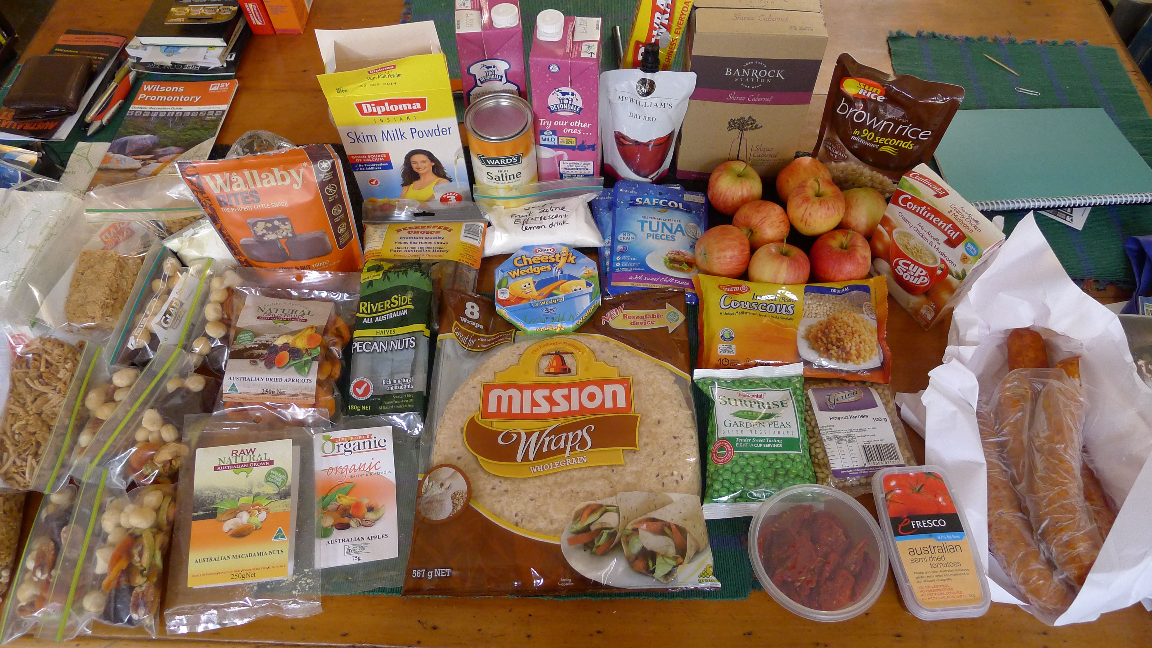
This is what we’ve come up with:
Hiking food – plenty for two nights away, I think!
Keeping in mind that the kitchens in each cottage at the lightstation are “fully equipped with stove, oven, microwave, fridge, cutlery and crockery”, we can take some items we wouldn’t otherwise.
Here’s the plan for 3 days and 2 nights:
Breakfast – Cereal (weetbix for me with a few sultanas, Stephen prefers other cereal) in a ziplock bag x 2 each
– powdered milk (for me) in a ziplock bag
– 1L UHT milk (for Stephen)
– Honey straws (optional)
Trail Snacks 3 x mini ziplock bags each (one for each day) comprising: – Wallaby Bites – fruit, nut & grains coated in dark chocolate – Australian owned & made. (Found with gluten free products at our local IGA supermarket & organic shops) – Australian Dried Apricots (Stephen’s not a fan of Turkish apricots – whether it indicates style or country of origin) – Australian Pecan Nut Halves (we think Riverside taste the best – they’re in the cooking ingredients section of our local IGA) – Australian Macadamias (I’d hope there aren’t any imports on our shelves!) – Australian Dried Apples (Incredibly hard these days to find dried apples not from China. These were also at our local IGA, though they weren’t easy to find)
Lunch – Mission Wraps (this time it’s wholemeal, but mainly because we couldn’t find a Spinach or Tomato flavoured pack). Why wraps? Because bread squashes and crackers break.)
– Spicy chorizo
– Sun dried tomato
– Kraft cheestick wedges
– fresh apples
– lunch wrap (we planned to make the wraps at the cottage before-hand)
Dinner We’ve tested this concoction at home and hope this will be enough for two nights:
– 1 x 250g pk Israeli (pearl) couscous
– 1 x spicy chorizo
– 1 x 100g dehydrated garden (green) peas
– 1 x 100g pinenut kernels
– 1 x 150g semidried tomatoes
– 1 tbs paprika
– 1 tbs oregano
– 1 tsp ground cumin
In case it’s not enough we’re taking extra food. It’s not fun to walk on an empty stomach!
– Sunrice medium grain brown rice that can be microwaved in 90sec (I hope the microwave is working if we need it!)
– Safcol tuna pieces in foil pack (x 2)
– Continental Cup-a-Soup (2pkt)
(Post-walk note: We didn’t need the extra food. The couscous was definitely enough. Fortunately there is a spare food draw at the cottages. Although the contents of the draw in our cottage when we arrived were just half a dozen packets or so of packet soup and a couple of sachets of salt, the next guests having a gander may have been surprised to find the rice, tuna, and a couple of extra tubes of honey I didn’t use up on my weetbix. And in case you’re wondering, we’ve definitely had our fill of chorizo, salami, etc for a good while now.)
So for food, I think we’re doing ok. Which just leaves…
Drink What’s wrong with water you ask? Well, nothing. But a glass of something else is enjoyable too.
– 1 x McWilliams Dry Red Clarsac Sachet 250mL ($3.50 from the bottle shop attached to our IGA. I don’t think I’ll be drinking much)
– 2L cask Banrock Station Shiraz Cabernet (No, Stephen won’t be lugging the whole 2L down, but he wanted something better than my unknown brand sachet option)
And because there’s every chance that I may get there and want something non-alcoholic, yet tasty
– Ward’s Fruit Saline Effervescent lemon drink – powdered chocolate drink
(Post-walk note: The saline effervescent drink was a lifesaver. If you’re contemplating walking to the lighthouse in one go like us, I would highly recommend taking some sort of hydrolyte/electrolyte/replenishing tablets or powder, just in case. The weather forecast was for mild conditions – instead it turned out to be pretty hot and I arrived quite dehydrated.)
So a two night limit is probably a good thing for us – who knows how much food we’d think we should take if we were able to stay longer!
Sunset colours the clouds at Wilsons Promontory Lightstation – two nights is just not long enough!!
Of course, there’s one more dinner and breakfast to plan for – once we return from our walk (we’ll be way too tired to drive ~3hrs hours back to Melbourne). We’re staying again at Black Cockatoo Cottages just outside the park for one night again after our walk (about 30min drive from Tidal River), so we don’t have far to travel. Even so, because the food will be left in the car while we’re in the park for a few days we need to take something that doesn’t require refrigeration.
(Post-walk note: We found out that the general store at Yanakie does a great take away fish & chip – with a very generous serving of chips. I’m not sure if they do it every night or not. Best to check ahead.)
So apart from food, what else do you need to pack when visiting the lighstation?
Parks Victoria doesn’t have a kit list – not even for novice do-it-yourself overnighters. Of course we have a pretty good idea of what to pack for ourselves, even though we only use our ~80L backpacks once every 3 years or so.
(If you don’t, check out this Ultimate Hike’s page on What To Bring. Keep in mind that Vic Parks won’t be supplying back packs and raincoats!)
Our room in the Lighthouse Keepers Cottage, almost packed
What is provided at the lighthouse are bunk beds with pillows and pillowcases. If you want to use a doona you can pre-book and pay for one through the Visitor Centre prior to arrival, although taking your own sleeping bag is also on Vic Park’s list of Things To Remember. Either way, you must take your own sheet(s). Stephen and I both have compact sleeping bags (1kg & 500g respectively) and silk inner liners (at less than 150g, much lighter than cotton sheets! Dare I ask – who’d take those?), but we’re glad there are pillows provided.
To help care for the environment, guests are asked to bring phosphorus free shampoos and soap.
The lightstation is powered by diesel generators, so while power is available (with no discernible cut-off time), visitors are requested to help save power and keep lights turned off. To keep power usage down each cottage is filed to capacity before another cottage is opened for guests.
Guests do not need to take cleaning products (detergent, sponge, scourer, tea towels), toilet paper, cutlery or crockery for use at the lightstation. I’ll put more details and photos about staying in the cottages in my next post.
Wilsons Promontory Lighthouse on a mostly clear night
Keep in mind, you don’t have to be crazy about lighthouses to enjoy being there. There’s also sunrises, sunsets, wildlife, cliffs, passing ships, fascinating history…. it’s most definitely worth the walk.


 & previous methods of illumination - Wilsons Promontory Lighthouse - South East Point")


 - Wilsons Promontory National Park Lightstation")
 - Wilsons Promontory National Park Lightstation")


 - Eulamprus tympanum - Oberon Bay Walking Track - Wilsons Promontory National Park")


 Pacific Gull - Larus pacificus - Wilsons Promontory National Park")

 - Sterna bergii - Wilsons Promontory National Park")


 - Wilsons Promontory National Park")


 in the distance - Wilsons Promontory National Park")


 weather station, Rodondo Is (TAS) in the background - Wilsons Promontory National Park Lightstation")
 and the Parks Victoria Keepers cottage (right) - Wilsons Promontory National Park Lightstation")

 - Wilsons Promontory National Park Lightstation")


 - just some of the more obvious reasons for the lighthouse - Wilsons Promontory National Park Lightstation")