
A spectacular walk showing off the contrasting habitats, magnificent geology, and spectacular scenery of Grose Valley. This walk contains many stairs, potentially slippery surfaces and a short tunnel. Check conditions at the Blackheath NSW Parks Information Centre if there has been recent heavy rain and, as always, be aware the day’s fire danger rating.

Start/Finish: Grand Canyon Loop Car Park, Evans Lookout Road, Blackheath
Distance: Approx 7.4km (Officially 5km, but I’m not sure if that includes the distance between Evans Lookout and Neates Glen Car Park. Also, satellite signal for our GPS’s was extremely patchy in the canyon)
Time: Approx 3hrs
Difficulty: Medium

Following our successful early morning walk to Leura Forest (by successful I mean we started and finished before noon!) we were primed for an afternoon walk to pack in as much as possible on our last full day in the Blue Mountains.
Even though there were still walks around Katoomba where we were staying (eg Wentworth Falls), if it meant a drive in the car we thought we may as well see a different valley altogether.
The Grose Valley is a very large, long valley to the north of Katoomba. There are many walks dotted on our SV map near the town of Blackheath, situated at the western end of the valley. The Grand Canyon is briefly described on that map, but we also bought a much more detailed Walking Track and Visitor Guide solely on the Grand Canyon walk from the Echo Point NPWS Information Centre (and at $3.00 you can’t quibble at the price).

Blackheath is an easy 10min drive up the road (west of Katoomba). The turnoff to this walk is before you get to the actual township, if you’re coming from Katoomba like us. There are signs, but keep your eyes open all the same as you get close to the town.
Following the instructions in the NPWS booklet, we parked in the Grand Canyon Loop Car Park (the second of three car parks) near the end of Evans Lookout Road. Somewhat surprisingly, there was another car in the first (Neates Glen) carpark, but no one else in the second. Judging from the number of car spaces available, this area can be pretty popular sometimes. Once again I found myself thankful it was a weekday, and not during school holidays.

Grand Canyon Loop Carpark is quite large…and we had it all to ourselves
Just like over at Jamison Valley, the vegetation atop the ridges here is tough and dry, full of prickly acacias and rough-barked banksias, scrubby grasses and brakenfern. There’s no hint here of the Grand Canyon just a stone’s throw away, nor what it contains…
On the other hand, it’s no stretch to imagine how an uncontrolled bushfire could race through and decimate communities living here – human, plant and animal. With our climate changing leading to the frequency and intensity of fires increasing, even communities that are fire tolerant will come under pressure.


The path leading back up to the first carpark (Neates Glen) was easy to find. There’s a very gentle incline on the path between the two car parks to the start of the proper Grand Canyon track. But pretty much as soon as you turn into the bush you’re walking downhill, increasingly steeply.


It was only early afternoon, but the shadows on the western side of the ridge felt cool and welcoming as we dropped below the ridge line. The undergrowth becomes softer, and it’s not too long before we came to the first set of doors across the path.

Doors? What on earth are these for?
To keep walkers out of areas affected by flooding, apparently. A good idea, but I wonder if the Rangers are sent to close the doors before or after the rain ?
Stepping through the first black door was like passing through a portal to a parallel universe. Almost immediately the vegetation becomes lush – not just beside the path – completely surrounding you, as you carefully make your way down the rock and concrete steps.

 - Grand Canyon Walk, Blackheath, Grose Valley, Blue Mountains National Park")


- Grand Canyon Walk, Blackheath, Grose Valley, Blue Mountains National Park")
There is water trickling over the path, down the boulders next to you, off every piece of moss and fern frond, after having been filtered through and slowly released by the hanging swamps above. Looking down to check my next step, I was amazed at the volume of plant life growing on the vertical rise of the step – in fact, there are ferns and mosses growing on every millimetre of surface that’s not regularly trodden, by the look of it.

Mosses growing on the vertical rise of each concrete step
Too soon the narrow gully widens and we found ourselves in a small valley. I thought at the time that these cliffs towering up to 100m above formed the ‘Grand Canyon’ referred to in the title of the walk… but this is just the start.
While nowhere near as large as the ‘real’ Grand Canyon in the USA (not even a speck compared to that) it is still impressive as you cross Greaves Creek for the first time and follow the canyon (aka gorge) down to the valley floor.


It’s not far before you reach the end of this upper, open section of the canyon, where a flight of stairs takes you down a level to a place known as the “beach”, I guess due to sand deposited here over time by the creek. It used to be known as the “Rotunda”, and was quite a popular spot. It’s not hard to see why. The afternoon sun was just at the right angle for a ray of light to pierce through the canyon onto the stream and yellow sand of the creek bed, illuminating the canyon wall with a dancing, golden light.


Tearing myself away from this fascinating area, we came upon the tunnel. In my brief scan of the NPWS notes over lunch I hadn’t noticed anything about a tunnel!
Fortunately Stephen had come prepared! Fishing the small torch out of his backpack we ventured in…


So it turns out it’s only about 5 metres long – but not knowing that I was happy for the torch. No, we didn’t get out and re-read the notes (also in Stephen’s backpack), but in case you’re wondering, it’s simply described as ‘a short tunnel having been formed by a rock fall’ and walkers are warned to “watch your step (and your head) as the floor of the tunnel is rough”. I didn’t notice it was particularly rough, but then – Stephen had brought a torch!

Looking back up at the tunnel’s exit
Before you, after you exit the tunnel and walk down the steep stairs, is a… bowl? basin? a gigantic pothole ground out by a million seething swirl pools of debris after eons of flooding? I’m not sure how to properly describe the large round space. The middle of the floor is filled with large boulders and a few trees, while ferns and other plants grow down the sides of the canyon walls. The path continues to hug the canyon wall on the right and, by so doing, leads you under a waterfall that feeds Greaves Creek.

The path leads behind a waterfall – not flowing too strongly today
It wasn’t flowing very strongly that day, so the only reason I got just a little wet on the shoulder was because I had to wait for Stephen to be satisfied with the photographs he was taking. But fair’s fair – it was his turn next!


 soon becomes much deeper than thisGrand Canyon Walk, Blackheath, Grose Valley, Blue Mountains National Park")

Entering the canyon proper I was awed by the rocks, shaped by the passage of water over millennia. The NPWS booklet explains the canyon is formed from what’s known as Burra-Moko sandstone. Not only does it look different to the Banks Wall sandstone that is widely recognised from photos of cliffs (most notably the Three Sisters) in the Blue Mountains, but it’s a softer sandstone, too.
The creek disappears from view down into the narrow, dark depths of the canyon. Ferns line the sides of the canyon walls, using any crevice, crack or ledge for support as they unfurl their fronds to catch the limited daylight – and the constant drip of water from the hanging swamps above – entering the confined space.
 this large and close - Grand Canyon Walk, Blackheath, Grose Valley, Blue Mountains National Park")
 - Grand Canyon Walk, Blackheath, Grose Valley, Blue Mountains National Park")


Walking across the scalloped side of the canyon, and through the cuts gouged into the walls made by the creek (some places deeper than others) I marvelled at the power and beauty of nature. For someone who loves rocks (in a forest setting), this was a place I could have only dreamed of prior to now… In short, it was fantastic.
Just before you descend to the valley floor, the canyon widens and the path transects some scrubbier forest on the hillside. The opposite side (much more of which is now visible) is topped with tall and straight eucalypts, silvery in the fading afternoon light.


 - Grand Canyon Walk, Blackheath, Grose Valley, Blue Mountains National Park")
 has widened enough that trees are able to grow at the bottom - Grand Canyon Walk, Blackheath, Grose Valley, Blue Mountains National Park")


Although it’s still only mid-afternoon, when you’re down this low in the protected canyon it feels a lot later. The light is fading quickly so we’re trying to hurry, yet at the same time at almost every turn there is a new sight to take our breath away.
Turning a corner and entering the gully that would reunite us with Greaves Creek, my immediate impression was that this would be just the sort of place to find elves (the benevolent kind); mossy and green, and perfectly arranged.

Tall straight trees trunks are a stand-out feature of this mossy gully leading down to Greaves Creek

Ferns quickly populate the gully as you descend this magical gully to Greaves Creek
As mentioned, there hadn’t been all that much rain lately; while there are a few small sources of water feeding into Greaves Creek along the way, it’s just enough to keep it flowing. The deep, dark pools of water are calm and cool. I wouldn’t be surprised if there are leeches in the water though, and drinking from the creek is definitely unsafe without sterilisation. There was no chance of getting our feet wet as we crossed the creek a couple of times on perfectly spaced stepping-stones as we followed the track down to the intersection with Rodriguez Pass Walking Track. The NPWS notes warn that you may have to look carefully in places to follow the track; this might be the case when the water level is higher, though we didn’t have any problems following it.


 is really quite magnificent even this far along - Grand Canyon Walk, Blackheath, Grose Valley, Blue Mountains National Park")

The size of the tree trunks lying discarded in, or propped up against the walls of the canyon are evidence of the power of past flood events. It looks like it’s been a while since the last big flood. Or maybe they’ve fallen down from above… either way, I’m glad everything was quiet as we walked through. The logs there have a reasonable covering of moss, and there are plenty of young trees and ferns growing the canyon floor.
Near the track junction the creek forms a very small waterfall as it enters the roof of a little cavern and fills a pool with a sloping edge of fine gravel (almost sand) by the path that looks absolutely perfect for a quick dip. Lucky it wasn’t a particularly hot day or I might have been tempted to stick a toe in. Or simply walk in, boots and all!


Rodriguez Pass Walking Track will take you into the middle of Grose Valley before exiting at Govett’s Lookout. Had we started this walk at 8am then this may well have been the route we would have taken. It would mean an extra 6-7km (at a guess – I haven’t got a map that tells me exactly) which I expect would take about 3hrs (definitely allowing time for photo opportunities!) plus a lunch break.

Junction with Rodriguez Pass Walking Track
After the intersection it’s pretty much all uphill back to the car park. As Stephen is known to sagely remark, “What goes down, must come up.”. Take heart in knowing the climb out is not as steep as any of the ‘Staircases’ we’d climbed in the last couple of days, because (for once) the track leads up a sloping gully to the cliff top instead of trying to scale the cliff itself! After climbing Giant Staircase that morning the climb out did seem to go on and on… and on some more, but on the other hand, it had been a lovely, long stroll to the bottom.


The air was already beginning to take on its evening chill; very pleasant in summer, but I imagine it can get really cold in winter! To begin with you’re still surrounded by lush forest, down on the valley floor where streamlets feed into Greaves Creek. Further up the gully the undergrowth thins out allowing a better view of the moss-covered trees and rocks along the path and the huge boulders and cliffs behind the reaching skyward.
With every step (and there are a lot of steps!) the mossy forest gets a little drier until there are just a few trees below two very large boulders. Climbing the stairs between them (here it was steep enough to put in a hand rail and, yes, I gratefully accepted) we emerged back into a eucalypt dominated forest – Blue Mountain Ash. Goodbye to the lush fern and moss adorned rainforests below, and surely, just at the top of this rise – hello Evans Lookout?!


But we weren’t there yet. Not until we’d climbed the dirt track up the hill, through the last gate and passed the information plaque (for people walking the circuit clockwise) could we breathe a sigh of relief. And then gasped in amazement, since this was our first look across Grose Valley! Magnificent! However, Evans Lookout is a still bit further on – another ~500m, but fortunately it’s just a gentle incline along the ridge to get there.


Anxious about being too late for a good sight (and photo opportunity), we didn’t dally but hurried along to the proper lookout and – thankfully – managed to arrive in time to snap a few photos in which the opposite cliffs were simply glowing in the late afternoon light. Mission accomplished!
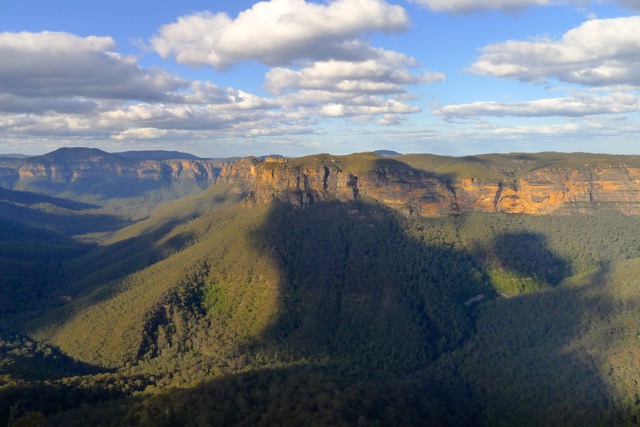
Grose Valley is more intimate than Jamison Valley

Grose Valley, whatever time of day, really is much more impressive than Jamison Valley. The cliffs on the opposite side of the valley are closer, and positioned so even amateur photographers can catch their evening glow. There are many interesting geological formations, walks, and even an impressive waterfall (Govetts Leap) that can be appreciated from a lookout adjacent to a car park – for free! It’s so big it’s hard to capture properly in its entirety, and possibly relief at finally being at the Lookout enhanced my experience, but there’s no doubt that it’s a magnificent location.

Easy steps back to Evans Lookout Car Park, past the distinctive shelter design used around Blackheath
Photos taken it was time to set ourselves for the last few hundred metres (which felt more like a kilometre) back to the car to complete the circuit.

It was a short, if damp, walk back to the Grand Canyon Car Park
Done! And what a walk that was!
I think most amazing aspect of this walk is discovering a completely different and marvellous world so very well hidden and remarkably close to town. In a relatively short walk you journey from dry, grey bushland to wet, fern-filled gullies, through a deep canyon carved out over hundreds of thousands of years, beneath the canopy of a sub-tropical rainforest, and finally by a small forest of beautiful Blue Mountain Ash. Walking under and past waterfalls, over the creek more times than I can remember, reinforces that it’s water – that most precious of commodities on our dry continent – that created and continues to shape this environment. Even the drops of water falling down from hanging swamps above giving the impression that it’s raining contribute to shaping tomorrow’s Grand Canyon.
Of course, this route wouldn’t be accessible without the enormous amount of work done by NSW NPSW to map out and create the route, install the small bridge, a few kilometres of handrails and fencing in places, and even more than a couple concrete steps which would have been made on site. An unbelievable amount of work has made it possible for the public to come and appreciate this jewel in the Grose Valley, and I, for one, heartily thank everyone (past and present) who has been involved in setting up and maintaining these walking tracks.
When we return, we’ll definitely be re-visiting the Grose Valley. There’s a lot more to discover here.
: )


 - Leura Forest, Katoomba, Blue Mountains National Park")


 overhead - Blue Mountains")


