Ok – here’s the bad news straight up. There’s no hiking on the 5th day. Well, I say ‘bad’ news, but by this stage a lot of the group think it’s actually a wonderful thing! On the up side, here’s the view you could wake up to:
Mitre Peak from our room at Mitre Peak Lodge
The reason Ultimate Hikes make this a 5 day experience is because once you’ve walked all the way to Milford Sound, who’s NOT going to want to go for a cruise out on Milford Sound before going home? The bone of contention is when people realise the advertised 5 day / 4 night guided walk includes only 3 full days of actual hiking in the wilderness. But damn it’s worth it!
The clouds that float around the mountains are fantastic. The many moods of Mitre Peak – we were lucky to see it in such spectacular form.
Everyone had packed an extra change of clothes in an overnight bag that Ultimate Hikes had sent on ahead from Queenstown on Day 1. Not having to wear the same hiking gear for the 5th day in a row – on the last day when we weren’t even hiking – was very nice.
Of course, you do have to do a wee bit of walking today – from your room to the bus, from the bus to the ferry, around the ferry while taking photos… you get the picture.
Our boat
Local Maori tribes used to visit Milford Sound, that they called Piopiotahi (after a now-extinct bird) to collect pounamou (greenstone) to make into tools and jewellery. They walked the same route through the mountains as we did, over what is now known as Mackinnon’s Pass. Read more here.
The Lady Bowen Falls, a modest 162m
No matter who you travel with, there are a few things every boat operator on the Milford Sound will do. One of them is going right up to a waterfall cascading down the side of a cliff… one might even say under it!
Approaching the waterfall
Having a shower, Milford Sound style
Leaving the waterfall we were just under
The point of this ‘stunt’ is to prove that the cliffs continue down below sea level just as steeply as they appear above it. Milford Sound, and I believe all the other ‘sounds’ in the region, is actually a fiord (thus why the region is called ‘Fiordland’), which means it was (Ages ago) a valley carved by a glacier, not a true sound which is a ‘drowned river valley’. Because the fiord is extremely deep, even very large cruise ships can approach the cliffs without fear of running aground.
Steep green thickly-forested mountain sides. One of the few stony beaches near the mouth of the fiord.
Another way to see the sights – if you have time!
Looking back down Milford Sound from the mouth
Seals!
There used to be a sealing colony along the coast that was set up in the 1790’s. A sailor on good ole Capt’n Cook’s ship came back because he remembered there were so many seals here when they called by. It ran for 30 years until they ran out of seals to slaughter. So they turned it into a whaling station and repeated the story.
These guys just have to watch out for the occasional orca pod (aka killer whales)!
Not only did we see seals (that’s almost guaranteed), but we were lucky enough to see a small pod of bottlenose dolphins and two rare New Zealand Crested Penguins!
New Zealand Crested Penguins
The dolphins were interested in feeding, not playing, so weren’t interested in interacting with us.
I was keeping my eyes peeled for whales – orca or otherwise – which are not common, but not unheard of visitors, but no luck this time.
Another waterfall shower
The wind created by the falling water and the impact of the water itself create a shattered glass effect on the fiord.
Underwater observatory (bottom left) in Harrison Cove, with a view behind of Pembroke Glacier
We didn’t have time to stop at the underwater observatory today, but I have been before and it’s definitely a worthwhile stop.
Although I enjoyed the cruise, one thing I noted was an absence of commentary from the captain/crew/someone about what we were seeing. A few years prior I had booked the cruise through Real Journeys (we were also on a Real Journeys boat on this trip), and the commentary along the way was very informative.
After the cruise we were back on the bus for the long ride back to Queenstown.
The road from Milford Sound up to the Homer Tunnel
I was pleased that Stephen would get to see the Homer Tunnel – I’d been mentioning it quite a lot in the lead up to the trip. It’s about 1km long, straight through a mountain – a great engineering feat in my opinion. Done mostly by hand and dynamite, it took a while to complete as work was interrupted by WWII. They dug it from both sides at the same time and met in the middle – and were out by less than a foot! Can you imagine trying to work that out? It’s a phenomenal achievement!
The cirque at the head of the valley on the Milford side of the Darran Mountain range
Entering the Homer Tunnel, Milford Sound side.
Looking back the Homer Tunnel exit, so small in the mountain side.
You can appreciate why avalanches and landslips close this road so often. The mountains here are just so steep and massive.
Driving down the valley; it looks harsher than the Clinton Valley.
A waterfall we passed right on the side of the road – you can pull over here if you’re in a car and heading towards Milford Sound.
I just can’t get over the water. It calls to me.
Despite the scenery, we were too tired to stay awake for the whole trip back. If you’re ever in the area and you have a chance to drive the road from Te Anau to Milford Sound – do it!! It’s a beautiful drive, and there are a few very worthwhile stops along the way that you just don’t get to do with a group. Definitely a case of enjoying the journey, not just the destination.
Oh, but remember – if you have to stop at the Homer Tunnel entrance, don’t leave your car unguarded to possible Kea attack!
We arrived back in Queenstown just before 4pm. We had a list of contacts (names & email addresses) for people in our group if we wanted to keep in touch… but we haven’t. Quite unlike our last infamous multi day hike, there wasn’t the same sense of group bonding on this trip. Not with the guides, not with the other guests. It’s hard when it’s a large group, when you’re not necessarily sharing a table with the same people each night, when you’re all wearing name tags and making more of an effort to find solitude and serenity on the walk than the opposite…
Don’t let me give you the impression that I have any regrets though! I don’t think we would do this as independent hikers, so Ultimate Hikes has allowed us – and so many others – to see a real jewel in New Zealand’s crown. I would recommend it to anyone who’s up for it!
We didn’t have a dinner reservation that night, but ended up at Wai on the waterfront. Top notch.
Dinner on the pier at Wai, Queenstown. The TS Ernslaw is setting off for it’s evening cruise.
Another early start for our last day of walking! Today we had a long (13 miles; 21 km), if relatively flat, way to go to get to the ferry at Sandfly Point.
Pretty flat compared to Day 3! Piece of cake…right?
Just like yesterday the lights came on at 6.15am. The first ferry would leave at 3.15pm, the second at 4.00pm. If there were still straglers, the boat would do an extra trip at 4.45pm. Sounded easy enough – 3km/hr would get you to there in time for the first ferry which also allowed for 45min of stops along the way… even so it felt like we had to walk at a pace just as fast as the previous day.
Signing the guest register in the Lounge area at Quintin Lodge
Making lunch at breakfast – Quintin Lodge
Thus it was with a few minor aches in our hips (thanks to the steep Emergency Track yesterday) that we set off, but as Stephen said, they either fixed themselves or got too numb to feel after a while!
Our packs weren’t feeling any lighter by this stage, and as I mentioned in an earlier post, as we’d chosen to bring our own larger packs we hadn’t felt so constrained about what we brought along – or rather, what we would have to leave behind to make necessities fit in. Not only was Stephen carrying a full shaving kit (not recommended), but also his iPad (definitely not on the kit list) and rechargers. I wasn’t carrying too much extra than my own phone and camera recharger. There’s no reception along the track, of course, but since the rooms were powered our plan was to take as many photos as we wanted each day, then load them onto the iPad of an evening and clear the camera’s memory card for the next day. Since we were carrying all our valuables with us (and the iPad, not long on the market at this stage, definitely fell into this category) it made sense to use it instead of having it purely as dead weight. It was nice to lie in bed and look at our photo’s each night on a decent screen, too. We didn’t ask if we were the first to bring an iPad along, but I’d wager we probably were…
Ready for our last walking day – still dry here, but not for long!
Although we’d had wonderful weather so far, today was a more typical day in Fiordland; it was wet. The rain was falling steadily – more than a light rain, but not a downpour (which is not uncommon) – which continued until about mid afternoon when we finished walking.
Photographer Stephen
Looking back to Sutherland Falls
It was a hard day on our cameras. Despite being in a soft case in a pocket with a water tight zip, my camera got pretty wet. In the period when the rain slacked off a bit I’d carry it in my hand to help it dry out! Stephen’s wasn’t fairing much better, as the few splotches on some of our photos will attest. While the views were not as stunning as the previous two days, the clouds hiding and revealing the mountains and waterfalls, and the lush forest bordering the track were sights to savour none the less. We pushed ourselves again today; we weren’t the first out the door (we were hoping not the be the last ones actually!) so had ground to make up if we wanted to catch the first ferry.
Even a little bit of rain means a lot of water flowing across paths and into creeks
Pretty easy walking to start the day
In this weather a comfort stop requires a bit more effort. Here we’re at the third DOC Hut – Dumpling Hut – and fortunately under cover.
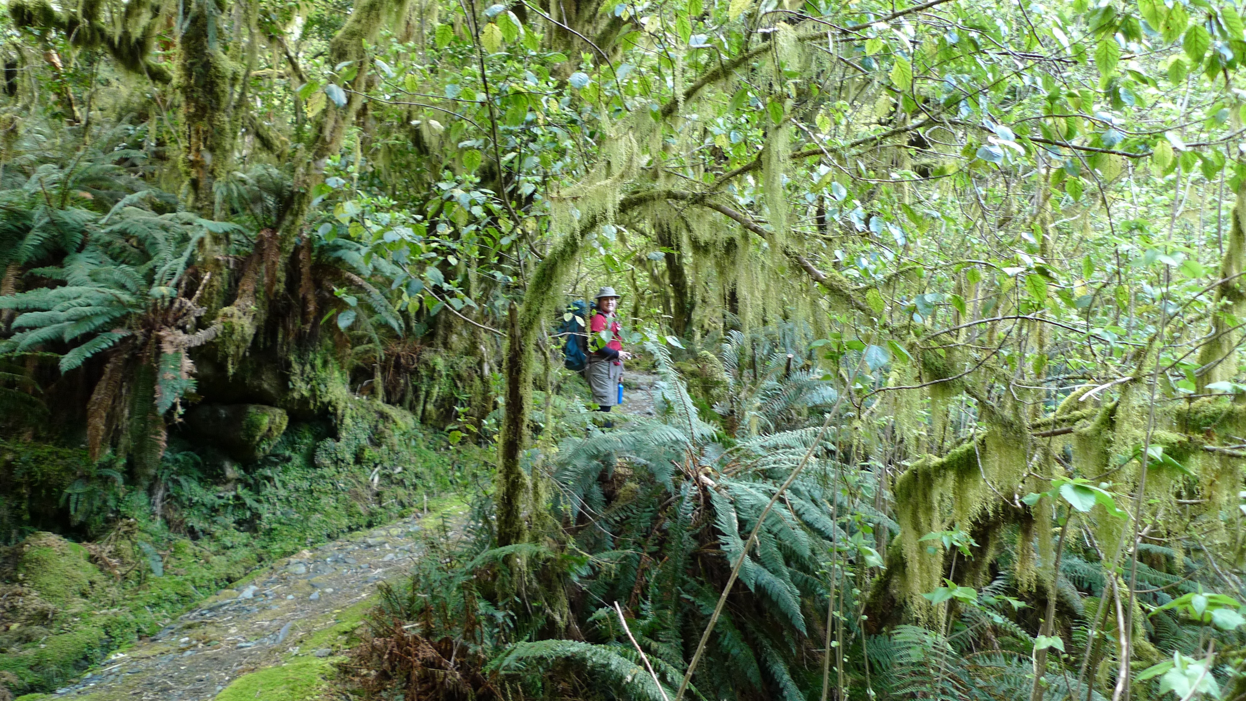
Lovely big mossy trees and lots of ferns.
Pretty damp by now.
My water resistant (not water proof) pants were soaked after the first hour or so, and although I was wearing gaiters, the water eventually crept down into my boots, making the last half of the day’s walk rather damp (didn’t get squelchy, though if we’d had to wade many streams they would have).
It was 8.8km from Quintin Lodge to our morning tea stop at the Boatshed – which felt like it should have been a lunch stop. Lunch was still a further 7.2km down the track yet.
The Boatshed
The thing I remember most about this stop was the number of sandflies around the entrance. There were so many sandflies today – whether they were out in increased numbers due to the rain, or maybe there are always more along the river in this valley – they are bloody annoying!
The shed doesn’t look like much on the outside but it’s not there to be glamorous. The inside is clean and a chance to take a seat and have a hot drink is most welcome at this point. There were fewer sandflies inside, fortunately, but the only way to keep them off is to keep on walking.
The rain wasn’t clearing any time soon
Stephen crossing the Arthur River. I just love the colour of the water! It’s so clear!
This raised section must indicate the water can get pretty high through here.
Before lunch we came to the other notable waterfall of the Milford Track – McKay Falls
McKay Falls
When Donald Sutherland and John McKay were prospecting in the area, back around the 1880’s, they came across this beautiful waterfall. I think the story that the guides told us went that McKay was keen to have these most beautiful falls named after him, and Sutherland acquiesced. Not too long afterwards, they were astounded by the giant falls which, they thought must be the highest in the world! Taking turns, as is only fair, were duly named after Sutherland. Later they were measured and found to be the 5th tallest in the world at 580m.
The stream leading away from McKay Falls
Passing through an open grassy section
Looking up at one of the many waterfalls fiordland is famous for. They get an annual average of 9m of rain on this side of the pass.
The track starts getting increasingly uneven and rocky.
Oh look, another waterfall. That’s a surprise.
Steep and just a bit slippery; it wasn’t a just short section either.
This section of track, completed in 1898, was carved out of the rocky cliff with pick axe and dynamite. It wasn’t a short section; I’m not sure now how long it took, but it would have been back-breaking work.
Despite the relatively easy grade of the track overall, the distance and the increased risk of slipping due to the rain had me wondering from the start if the lady who came in last the previous night would make the final ferry. We were taking the above cut-out section carefully when we saw the helicopter from yesterday fly low up the valley; not carrying anything on a cable this time. When it came back again a short time later my first thought was that it had been called in to chopper that lady out. When I suggested this to Stephen he wondered if it was only her who was flown out…
We guessed that if a walker doesn’t reach a certain point by a cut off time, the guides know they aren’t going to make it and call in the chopper (it’s not something they like to mention). That’s why you don’t walk without travel insurance! I don’t know how much it would cost you if you didn’t have it… hundreds at least. The guides were pushing the option of a helicopter ride back to Queenstown instead of going by coach after the cruise on the last day. Sounded good, but you need to have at least 4 people willing to go for $500+ EACH (I think it was closer to $600pp). At first we thought they meant the total cost was ~$500 – when we realised it was per person – ah no, thank you. Spectacular as the flight must be, we’re not independently wealthy.
A stoat trap baited with a chicken’s egg
I mentioned in an earlier post that feral animals are a huge problem in New Zealand. Their native vertebrate wildlife consists mainly of birds who have diversified to exploit all the niches that mammals would usually occupy. A number of these species are extinct thanks to humans; the introduction of european and Australian feral species has also had a devastating impact on native animal populations. Trapping of feral predator species, such as ferrets and stoats, in fiordland is done to help endangered populations of native species such as the Whio, among others. This trap is probably good for a smallish possum, too; another major feral pest.
Beautiful as it is, we were just looking forward to getting to our lunch stop.
Our lunch stop at Giant’s Gate. Raining again. Unfortunately still 1h 45m from Sandfly Point.
It’s a lovely stop that I think we would have enjoyed more on a sunny day and if we weren’t being ceaselessly attacked by sandflies.
The best photo I managed to get of a Weka.
Weka are often mistaken by excited tourists for Kiwi, however unless you go to a birdpark where kiwi are kept, you are extremely unlikely to stumble upon one in the wild. For starters, Kiwi are nocturnal and notoriously shy. Weka are also not as cheeky or destructive as Kea are! This Weka was happy to ignore us as it went about its business while we ate lunch, coming to within 1m or so of the tables.
Giants Gate Falls
The last 5.6km seemed the longest, but we got to Sandfly Point at about 3pm. I couldn’t wait to strip off my wet clothes; fortunately the DOC hut was empty so I used that to change into dry clothing for the ferry ride to the Milford Sound wharf. Again the difference between the DOC and Ultimate Hikes facilities were noticeable. No screens to help keep out sandflies on the DOC huts, for instance. I was changed in just enough before we had to leave to get to the ferry.
There was a photographer from Magic Moments at the 33.5 mile finish sign to take a photo of everyone who made it. Photo packs were available for purchase later that afternoon – which include a CD of photos of the track incase you didn’t come away with any good ones of your own, possibly, due to weather or choice. Can you tell we prefer to take our own?
Our official Magic Moment photo at the end of the Milford Track, and my name tag.
The final sign post is large and decorated with discarded boots. One girl had bought an old, comfortable pair of boots – she had worn them at home to test them, and they were fine… until the first or second day of the track. By the end her soles were only barely held on with tape and spare shoe laces. I don’t think she left them on the sign because they were all she had!
It was a short if somewhat unexpected walk to the ferry, and a pleasant if cold 20 or so minute ride to the wharf. At that point I was extra glad I changed out of wet clothes! Stephen was frozen.
Changed into dry clothes and feeling good!
New Zealand is also known as the Land of the Long White Cloud – here’s one looking like cotton wool.
Approaching Milford Sound – those small buildings to the right of the falls. That small white boat there is actually quite large one.
Mitre Peak Lodge currently operates mainly for Ultimate Hikes groups, although there are a few rooms for other people. It’s a nice place – Stephen says it feels like a nice kind of 60’s-70’s style university science facility. Doesn’t mean much to you? Plain but comfortable and nice. And you certainly can’t say the view isn’t any good. Mitre Peak rising out of the water straight out the front, either mysterious in the mist and clouds drifting like smoke, or standing proud and magnificent in the clear skies. Amazing.
Arriving at Mitre Peak Lodge – about a 2 min bus ride from the Milford Sound pier.
Inside the entrance of Mitre Peak lodge. Rooms above, drying room and gift shop below.
Lounge and bar area of Mitre Peak Lodge. The fireplace is made of greenstone – pounamou. These days (assuming you even had access to some) that would cost an absolute fortune!
Dining room in Mitre Peak Lodge
There was just one person who beat us there – the lady who was flown out. I felt sorry for her in a way – she had seen most of it and given it a go, but was it by choice that she was flown out? Should Ultimate Hikes be more strict about who they let start the walk? Again, I guess that’s what travel insurance is for. You set yourself a challenge and give it your best. And find out if you’re really prepared as what you hope you are!
Once everyone had had the chance to hang up wet clothes and relax in the lounge with drinks, bread and dips, we were presented with certificates to say we’d completed the Milford Track.
View of Mitre Peak from our room
Just a quick note if you’re planning to walk the Milford Track, there is a really informative booklet that you can buy that has notes about points of interest, shown on a progressive map where you flip over each page as you walk along the whole length of the track. We purchased our copy after we completed the walk. It’s more-or-less pocket-sized.
Fantastic guide to the Milford Track by Kiwi footpaths
We had finished walking the Milford Track, but the Ultimate Hikes Milford Track experience doesn’t end there: read Milford Track Day 5 to see photos from our cruise of Milford Sound.
Crossing Mackinnon Pass is definitely the most spectacular day of the Milford Track… and the day that I (and probably everyone else) was most worried about surviving in reasonable shape!
It’s this little bump in the path that was occupying everyone’s mind (see Day 2 for full track profile)
From Pompolona Lodge we would walk to the end of the valley, up over the pass, and down the other side to Quintin Lodge. Officially an 11 mile (17-18km) day, but again our GPS reading was a little different at 15km – there was, however, a good reason for the discrepancy (more about that later).
Mackinnon Pass from Pompolona Lodge, early in the morning. Mt Balloon is on the right of the pass.
Such is the apprehension felt by most prospective hikers when contemplating this section of the track that Ultimate Hikes has a devoted a whole page to what to expect on this day. As it turned out it wasn’t nearly as challenging as I’d feared.
Because it is expected to be a long, tough day, we we woken by the lights coming on even earlier that morning – 6:15am! – and we were to be on the track between 7:30-8:00am. Stephen and I had intended to be ready by 7:30am, but didn’t manage to get underway until 7:45am. We started out at a good pace, determined to make up a bit of time.
A wet forest
I was hoping to encounter snow/ice patches as we crossed the Pass. Even if we weren’t to be that lucky we knew it would very likely be cold up there, despite the fine start to the morning, as weather in alpine environments is notorious for changing extremely quickly. With those thoughts in mind we added long thermals underneath the shorts and t-shirts ensemble we wore yesterday – quite a fashion statement, I know, but not only does it work in keeping you warm, but out on the track no one cares what you look like (too much). Our jackets were also handy at the tops of our packs.
Looking back down Clinton Valley on another beautiful morning
Stunning, hey?
It wasn’t far to the next DOC hut where we stopped for morning tea, but we didn’t linger. It took a while to get to the start of the proper climb up and the 11 switchbacks.
Brief morning tea stop at Mintaro Hut – the second DOC hut for independent walkers
Almost at the switchback section – Stephen’s impatient to keep moving
I’m afraid I don’t have photos of what it was like on the switchbacks to share with you, incredible as that sounds. In our minds this was the challenge of the trip – the part that everyone talks about – the huge climb up to Mackinnon Pass. The part of the track that can turn into a waterfall when it rains heavily.
When it came to it, it wasn’t too hard… I think the start of Mt Warning (northern NSW, Australia) with all the steps is harder. Still, it was eyes down (due to the uneven surface) and legs moving as we kept up a steady pace (you might say a quick march!) and so caught up and passed a number of others (all labouring whilst trying to use their walking sticks in loose rocks!). I find keeping a steady pace is the key… too much stopping and starting is more wearying than staying in your rhythm and pushing on. Everyone’s different though – and the guides do stress that it is not a race.
Out of the forest, into the alpine section near the top of the pass
We weren’t far from the top when we caught up with the second guide who walked with us to the top. There were a couple of patches of snow before the top, but nothing much. Still, for a Queenslander, snow is snow! My wish had been granted. Stephen had his gaiters on, but I didn’t bother with mine, wanting maximum ventilation instead!
Looking back to Nicholas Cirque at the head of the valley and one of our guides
Woohoo! Snow! A wee bit, anyway. Mt Balloon rising up in the background.
There were a maybe half a dozen people there at Mackinnon’s monument before us. Claude (senior guide) pointed out the 12 second drop on the other side of the pass – the short (and terminal!) way down – from where we could also see our hut for the night (Quintin Lodge) and the old grass runway. Now that everything’s chopper’d in I don’t think it’s used anymore.
Stephen in front of Quintin Mackinnon’s Memorial with Mt Hart in the background
Standing next to Quintin Mackinnon’s Memorial with Nicholas Cirque in the background
Standing at the 12 second drop, looking down the other side of Mackinnon Pass to Quintin Lodge – this was taken with my standard (non-interchangeable) camera lens, not a fisheye or anything fancy. The airstrip points the way to Milford Sound.
Looking to the right from the 12sec drop, the track passes below Mt Balloon and down the gully (if you can call it that) between the mountains.
Pass Hut was still a short walk away, over a small hill that marks the highest point of the track. The weather was starting to close in from the west, but the view back down the valley were magnificent. They say the toilet there has the best view in the world, and I can vouch that, on a good day, they’re not far wrong!
Continuing on to the highest point of the pass. Mt Balloon rises before us.
Looking back to the Memorial and 12 sec drop lookout. Mt Hart to the left.
The landscape is BIG and can dwarf everything we do and achieve just by existing.
By the time we’d reached the sign marking the highest point of the pass – and the Milford Track – the weather was definitely changing
Altitude here is 1154m
We made it!! Looking back down the Clinton Valley – the way we’d come.
Pass Hut is designed just provide shelter from the weather during your lunch stop, not for camping in. It’s a long rectangular building divided in two: one side for independent walkers to use, the other side for the Ultimate Hikes group. Our side had a small kitchenette so that the guides can offer us a hot cup of soup or hot chocolate when we walked in. I don’t believe the other side had such luxuries. There are benches around the walls for everyone to park their rears – packs (and walking sticks) get dumped in the middle of the room.
Inside the hut; benches along the sides, and double entrance to keep out the weather. And two very nice DOC workers seeking a hot cuppa.
Despite the numerous steaming bodies at lunch quickly fogging up the windows, once we stopped walking it didn’t take too long to start feeling how cold it actually was.
After a big lunch, we shouldered our packs again and headed off. Stopping for just a few more quick photos…
Tutahuna / Common Vegetable Sheep (no, that’s not a typo – click here Raoulia eximia for an explanation)
Close-up of Tutahuna. Looks a little bit like coral to me.
Kopukapuka / Mt Cook Lilly (which is actually a member of the buttercup family)
This plant looks exactly like Pandani (Richea pandanifolia) which we are familiar with from around Cradle Mountain NP, but that species is found only in Tasmania (Australia). This is a Dracophyllum sp., possibly Dracophyllum fiordense, a related genus. (Ref)
Fiordland Mountain Daisy
We weren’t far from the hut when a chopper carrying a load at the end of a cable came up the valley in front of us and almost right over our heads! Seeing that load swinging pretty low in our direction was a bit frightening. It was possibly not as close as it felt, but we’d have been in trouble had the cable broken. It was bringing supplies packed in barrels to the two DOC workers who were working at the hut. The hut is brand new and they were finishing off the paths and garden area around the hut.
Chopper dropping off supplies for workers at Pass Hut
We continued on and down – a long way down. From the pass it’s 900m down to Quintin Lodge. If you ever have walked down the stairs of a high-rise building during a fire drill and thought that was a long walk and a bit hard on the knees, try multiplying it by however many times to get to 900m, take out the handrails, add in rain, backpacks and slippery stones and you’re nearly there. But the view on the track is infinitely better!
Another small bit of ice after lunch
Looking back to Mt Hart
A section near the top of the main track was closed due to avalanche danger from a nearby glacier, so we had to take the Emergency Track which leaves the main track after the 16 Mile post and meets up with it again before the 18 Mile post. Stephen managed to take a photo of every mile post on the way except for number 17, and the last one at the 33.5 mile mark at Sandfly Point which had a professional photographer there.
Main Track closed – instead of continuing across the hill, the Emergency Track heads pretty much straight down for a bit. Great use of a wheelbarrow.
The Emergency Track is steep and rough compared to the Main Track. Reminds me of a few tracks around Cradle Mountain.
Creative location for track indicator – but hey, it works!
Looking back up to Mackinnon Pass – probably about half way down in altitude but definitely not in kilometres (miles) to the lodge.
The descent wasn’t too hard, though I concede by the end even I was starting to feel my knees and hips – just a little. We didn’t dwadle, but took the time to be careful all the same. It had clouded over, and there were intermittent showers – we were lucky there wasn’t heavier rain. There were a couple of sections of boardwalk with plastic or chickenwire attached for grip – the guides had warned us that these sections can still be slippery and most accidents happen there because people subconsciously relax when walking on boards.
The first large waterfall we passed on the way down
I’m not sure why there were so few leaves on the the trees at the top of the forest. There was plenty of moss and ferns.
Crossed a few suspension bridges. Mt Hart in the background.
Lindsay Falls – possibly the lovliest we saw that day.
We were about half way or so down when we came to pass an older couple of independent walkers, who kindly moved to the side for us. I made a little slip just as we passed – I didn’t fall or anything – and made a comment that it doesn’t pay to be complacent. Just as we passed, the lady who was in front, demonstrated exactly why walking sticks can be hazardous. Seeing her next step could be tricky, she put her sticks on the smooth rock, took a step, the sticks slipped, and she was on her backside. Stephen helped her up and she was ok. It could have been worse – fortunately wasn’t – but walking sticks with metal points aren’t made for rocks. I wonder how many people in our group found that out in the same way.
An arching branch of ferns
Ferns on a tree
Lichen? on a tree
The track and bush around the last few km’s or so of the walk to the lodge felt very similar to Lamington National Park (Gold Coast hinterlands, Australia) – a well graded track of dirt and rocks with lush forest on either side. It was there that we heard the chopper flying in low again, and hurried over the last bridge to find ourselves at the end of the path and Quintin Lodge – finally! We were in time to get a few pics and see it fly off again. We were excited; I’m sure the staff were wondering what on earth for – hadn’t we seen helicopters before? Keep in mind they get flown to work in one – they really are a fly-in, fly-out work force!
A very busy helicopter!
The buildings that make up the Quintin Lodge complex are arranged in a square. Our room was again very nice, with a view overlooking the yard between the buildings with the mountains rising behind.
The view from our room at Quintin Lodge
Because today’s walk wasn’t nearly as long or hard as expected, we decided to do the optional side trip to Sutherland Falls which are the highest falls in New Zealand. The guides said that anyone who wanted to go should leave Quintin Lodge no later than 4.30pm as the walk takes ~1.5hrs (return). We had aimed to be at the lodge by 3pm, so would be back by the cut off time to start walking. We ran in (our entrance would have been at a more seemly pace if not for the chopper – although this isn’t our only walk that has ended at a run) to Quintin Lodge just after 2:30pm, which I guess means we more than made up for leaving 15min later than hoped that morning.
We dumped our packs and took only cameras, hats, and a water bottle and set off for the falls at about 2.45pm. We had been told to take rain coats/jackets too, but it had turned into a nice sunny afternoon and it didn’t look like it was going to rain. I figured it we got a bit of spray we’d dry out alright.
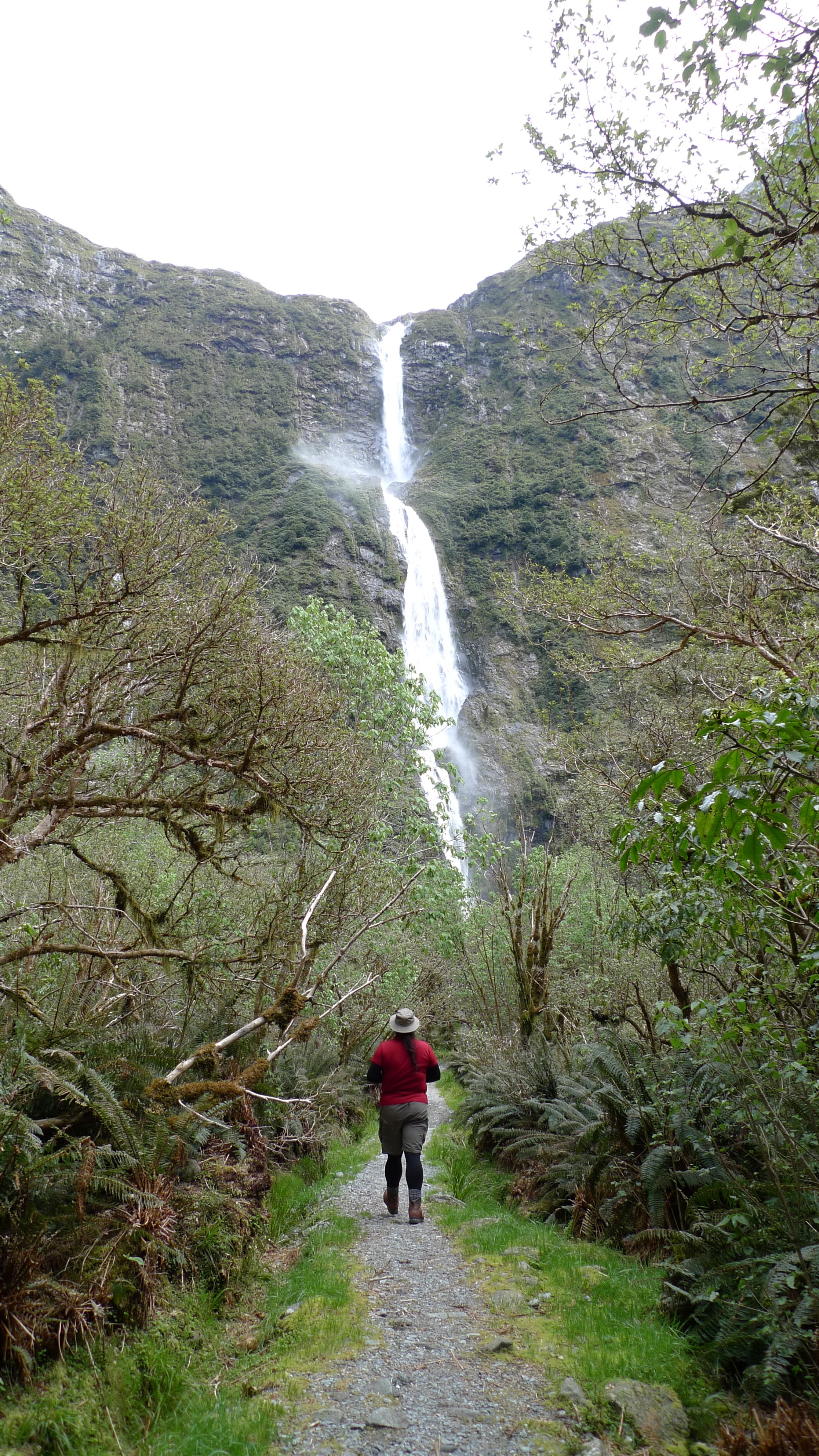
Donald Sutherland, who the falls are named after, was an explorer like Mackinnon but made his home where the Milford township now stands. He discovered the falls in 1880 while prospecting (unsuccessfully) for asbestos and brownite with John McKay (more about McKay in my next post; Milford Track Day 4). Later that decade the government paid him to cut an access track to Sutherland Falls; his track met up with Mackinnon’s track and together they make the Milford Track as we know it today. (Read more about Donald Sutherland here.)
Heading off to Sutherland Falls
At the start of the path the sign on the left says ‘Sutherland Falls 580m’ and the sign on the right says to allow 1hr 30min return. We thought “580m? No worries! We’ll be back in no time” and charged off at a good speed (now that we weren’t weighted down with packs). I couldn’t for the life of me think how 580m would take 45min…
We passed a few independents on their way back from the falls (they had a head start on our group this morning, but the DOC hut where they would stay the night was still a good few km’s further down the main track still); we were too focused on getting there to say more than ‘Hi’ as we passed – they probably wondered what the hell we were running from! We started to wonder… how long could 580m be?
It’s a lovely path – this is a little stream we crossed
We had slowed our pace from a jog to a brisk walk and were joking that maybe we had to climb 580m in elevation to get there when we came to an avalanche warning sign that said no stopping for 360m – we crossed that in minutes and by then it was rather obvious that 580m wasn’t how long the path was to the falls. A few minutes on we saw one of our party coming back along the track and he said we have about as far to go as the falls are high – and then we saw the sign saying exactly that; we were now 580m from the base of the falls – the same distance that they are high!! Important lesson that one – when you’re tired, you don’t think straight. We weren’t in any danger of getting lost on such a clear track and with a number of people around, but I see how easy it can be to get into trouble.
Human-sized fairy pathways through the forest
A Weka
Stephen spotted a Weka! Our second for the day – there was one up on Mackinnon Pass, too. They can fly but are predominantly terrestrial.
Approaching Sutherland Falls
The falls are very impressive, and the wind that the falling water creates at the base clearly explains the need for a raincoat. Despite a lot of spray we managed to take a few photos then turned back to return to the lodge.
Not a big pool, but the wind created by the falling water was quite strong
Sutherland Falls
Wide shot of Sutherland Falls
Damn it was good to finally take our boots off that night! Most people got to the lodge in time to take the walk to the falls. A few didn’t. One lady who was not a strong walker (around the hut she was fine, but as soon as she was on the track – sticks in hand – she walked like an invalid; very, very slowly and carefully, thinking about each step she took) didn’t get in until about 7pm – almost 12hours on the track. Just after lunch she’d fallen into a hole in the ice and had to wait 15min before the last guide came along to help her out! But she made it eventually. They do keep saying it’s not a race… On a previous trip a whole group didn’t make it to Quintin Lodge until 10.30pm! They were all flown to Mitre Peak Lodge the next day, since I guess they were all knackered and a group can’t stay more than one night in each hut – there’s up to another 50 guests a day behind ready to crash!
While that lady was probably in the worst shape of all of our group, she wasn’t the only one feeling relived today was over. Despite hiking boots being on the list of essential items, there was a couple on their honeymoon who were only wearing sneakers – and their feet were definitely talking to them! Most of the group were complaining about sore knees/legs/ankles. It really does pay to have good (broken-in) gear and to do some preparation before any hike of some length.
Our nightly powerpoint presentation reminded us that although Mackinnon Pass has been conquered, there was still a lot still to see (and walk!) on Day 4 on our way to Sandfly Point (the end of the Milford Track) and on to Mitre Peak Lodge.